|
search place name
|
||
Maḩmelīān (Hormozgān, Iran)Maḩmelīān is a town in the Hormozgān region of Iran. An overview map of the region around Maḩmelīān is displayed below.
regional and 3d topo map of Maḩmelīān, Iran ::

Maḩmelīān airports ::
The nearest airport is BND - Bandar Abbass Intl, located 85.9 km north west of Maḩmelīān.
Other airports nearby include KHS - Khasab (108.8 km south west), RKT - Ras Al Khaimah Intl (173.6 km south west), FJR - Fujeirah Fujairah Intl (200.6 km south west), SHJ - Sharjah Intl (225.6 km south west), Nearby towns ::
Rūtān (1.5km west) //
Karpān (2.1km south west) //
Gachīneh (4.0km north west) //
Yamānī (4.3km north west) //
Konārjū (5.1km south) //
Pālūr (4.8km north west) //
Shāh Mardī (5.2km south west) //
Labanī (5.4km north west) //
Bemānī (6.0km north west) //
Sargalm (5.8km west) //
Kūhestak (6.7km west) //
Kalāvī (7.7km north) //
Vādāsht (8.1km north west) //
Pātal (8.6km north) //
Gohardū (9.5km north west) //
[all distances 'as the bird flies' and approximate] 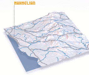 Places with similar names to Maḩmelīān, Iran ::
// Mamōlān (IQ)
// Momblona (ES)
// Mamaleón (MX)
// Māmālān (IR)
// Mambalūn (IR)
// Mumlān (PK)
// Maiembulani (MZ)
// Maimelane (MZ)
// Membelane (MZ)
// (( Maymulin )) (RU)
Disclaimer :: Information on this page comes without warranty of any kind |
||
|
Where is Maḩmelīān? Elevation and coordinates ::
Latitude (lat): 26°47'0"N Longitude (lon): 57°5'39"E
Elevation (approx.): 24m (map arrows pan, magnifying glasses zoom) |
||
|
Visiting Maḩmelīān? Hotel/Accommodation ::
Book a hotel in Maḩmelīān Travel Guide ::
Buy a travel guide for Iran rental cars ::
car rental offers GPS waypoint ::
download a GPX waypoint (PoI) of Maḩmelīān for your GPS receiver
|
||