|
search place name
|
||
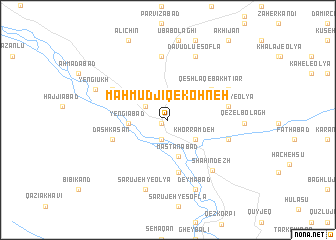
Maḩmūdjīq-e Kohneh (Ostān-e Āz̄arbāyjān-e Sharqī, Iran)Maḩmūdjīq-e Kohneh is a town in the Ostān-e Āz̄arbāyjān-e Sharqī region of Iran. An overview map of the region around Maḩmūdjīq-e Kohneh is displayed below.
regional and 3d topo map of Maḩmūdjīq-e Kohneh, Iran ::
Maḩmūdjīq-e Kohneh airports ::
The nearest airport is TBZ - Tabriz Intl, located 159.0 km north of Maḩmūdjīq-e Kohneh.
Other airports nearby include SDG - Sanandaj (169.3 km south), Nearby towns ::
Maḩmūdābād (0.6km south west) //
Khātūnābād (2.3km south) //
‘Abbās Bolāghī (2.5km north west) //
Khorram Deh (3.3km south east) //
Mastānābād (4.2km south) //
Yengīābād (3.5km west) //
Qeshlāq-e Bakhtīār (5.2km north east) //
Āqtappeh (6.0km south) //
Dāsh Kasan (5.5km south west) //
Jūshātū-ye ‘Olyā (5.6km east) //
Akhchī (5.8km east) //
Chīchaklū (6.0km north west) //
Qareh Tappeh (7.1km north) //
Shāhīn Dezh (6.9km south east) //
Khalaj-e Pā'īn (6.4km north east) //
Kahel-e Soflá (6.4km north east) //
Jūshātū-ye Soflá (6.4km north east) //
Dāvūdlū-e Soflá (7.5km north) //
Sārūjeh-ye ‘Olyā (8.0km south) //
Deymābād (8.1km south) //
Qezel Bolāgh (6.9km east) //
Yengī Ūkh (7.3km north west) //
[all distances 'as the bird flies' and approximate] 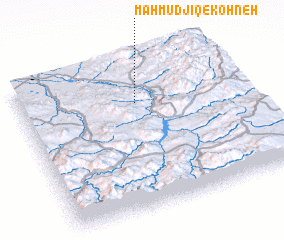 Places with similar names to Maḩmūdjīq-e Kohneh, Iran :: Disclaimer :: Information on this page comes without warranty of any kind |
||
|
Where is Maḩmūdjīq-e Kohneh? Elevation and coordinates ::
Latitude (lat): 36°43'11"N Longitude (lon): 46°31'22"E
Elevation (approx.): 1365m (map arrows pan, magnifying glasses zoom) |
||
|
Visiting Maḩmūdjīq-e Kohneh? Hotel/Accommodation ::
Book a hotel in Maḩmūdjīq-e Kohneh Travel Guide ::
Buy a travel guide for Iran rental cars ::
car rental offers GPS waypoint ::
download a GPX waypoint (PoI) of Maḩmūdjīq-e Kohneh for your GPS receiver
|
||