|
search place name
|
||
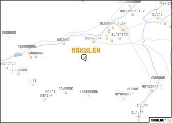
Mākūleh (Eşfahān, Iran)Mākūleh is a town in the Eşfahān region of Iran. An overview map of the region around Mākūleh is displayed below.
regional and 3d topo map of Mākūleh, Iran ::
Mākūleh airports ::
The nearest airport is QMJ - Masjed Soleiman Shahid Asyaee, located 177.7 km south west of Mākūleh.
Nearby towns ::
Rekābdār (4.4km north) //
Kocherī (5.6km north west) //
Robāţ-e Pīr‘alī (6.3km north east) //
Ḩasan Ḩāfez̧ (6.8km north east) //
Āblūlān (6.5km north east) //
Khoshkrūd (7.4km south) //
Arjanak (7.7km south west) //
Esfaranjān (7.7km north east) //
Robāţ-e Ḩoseynīyeh (8.1km north east) //
Sūr Bāţān (7.9km north east) //
‘Alījān Khvājeh (8.9km north east) //
Golpāyegān (9.6km north east) //
Kahrt (9.8km south west) //
Dīyār Qolī (10.5km south east) //
[all distances 'as the bird flies' and approximate]  Places with similar names to Mākūleh, Iran ::
Disclaimer :: Information on this page comes without warranty of any kind |
||
|
Where is Mākūleh? Elevation and coordinates ::
Latitude (lat): 33°23'28"N Longitude (lon): 50°12'54"E
Elevation (approx.): 2003m (map arrows pan, magnifying glasses zoom) |
||
|
Visiting Mākūleh? Hotel/Accommodation ::
Book a hotel in Mākūleh Travel Guide ::
Buy a travel guide for Iran rental cars ::
car rental offers GPS waypoint ::
download a GPX waypoint (PoI) of Mākūleh for your GPS receiver
|
||