|
search place name
|
||
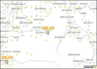
Maleh (Iran)Maleh is a town in Iran. An overview map of the region around Maleh is displayed below.
regional and 3d topo map of Maleh, Iran ::
Maleh airports ::
The nearest airport is THR - Teheran Mehrabad Intl, located 173.9 km south west of Maleh.
Nearby towns ::
Par Chīnak (1.6km north) //
Seyyed Abū Şāleḩ (2.4km south) //
Seyf Kotī (2.4km west) //
Reykandeh (3.5km north west) //
Bīsheh Sar (4.2km south east) //
Anārak Tīsī (4.1km west) //
Chepī (4.1km west) //
Arzefūn (4.5km south east) //
Afrātakht (5.4km north west) //
Setūn Kolā (5.1km east) //
Dalāk Kheyl (5.2km east) //
Gol Afshān (5.4km west) //
Kar Chang (5.6km west) //
Gīleh Kolā (7.1km north) //
Pahneh Kolā-ye Jonūbī (6.2km east) //
Galleh Kolā (7.5km north) //
Shektā (6.5km north east) //
Kord Kheyl (7.9km north) //
Mashown Kolā (6.6km east) //
Chāl Kīādeh (6.8km east) //
Darwār (6.8km east) //
Mehdīābād (7.5km north west) //
Būr Kheyl (7.5km north west) //
Jūjā Deh-e Araţeh (8.1km north west) //
Māhfrūjak (8.4km north west) //
Term (7.4km north east) //
Sheykh Rajeh (7.6km north west) //
Sang Tarāshān (8.1km north east) //
Abūkheyl-e Araţeh (8.4km north west) //
[all distances 'as the bird flies' and approximate]  Places with similar names to Maleh, Iran ::
Disclaimer :: Information on this page comes without warranty of any kind |
||
|
Where is Maleh? Elevation and coordinates ::
Latitude (lat): 36°26'11"N Longitude (lon): 53°0'35"E
Elevation (approx.): 209m (map arrows pan, magnifying glasses zoom) |
||
|
Visiting Maleh? Hotel/Accommodation ::
Book a hotel in Maleh Travel Guide ::
Buy a travel guide for Iran rental cars ::
car rental offers GPS waypoint ::
download a GPX waypoint (PoI) of Maleh for your GPS receiver
|
||