|
search place name
|
||
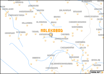
Malekābād (Lorestān, Iran)Malekābād is a town in the Lorestān region of Iran. An overview map of the region around Malekābād is displayed below.
regional and 3d topo map of Malekābād, Iran ::
Malekābād airports ::
The nearest airport is QMJ - Masjed Soleiman Shahid Asyaee, located 144.2 km south of Malekābād.
Other airports nearby include AWZ - Ahwaz (228.4 km south), Nearby towns ::
Khomestān (1.8km south) //
Deh Sefīd (2.4km south west) //
Kān Sorkh (2.4km west) //
Jahān Khvosh (3.2km south east) //
Bāvkī (4.4km north) //
Cherbās (3.9km east) //
Ālī Maḩmūd (5.6km north west) //
Ţāshal (5.1km west) //
Bāvakī (6.6km north) //
Cheshmeh Par (6.6km south east) //
Īvandeh (6.2km east) //
Deh Now (7.5km south) //
Ayūndeh (6.4km east) //
Kheyrābād (7.2km south east) //
Mālāshīr (9.0km north west) //
Deh Now (9.5km north) //
Pīrdezgāh (9.0km south east) //
Qalāvardīr (9.5km north east) //
Āb Bārīk (9.6km south west) //
Kondorcheh (9.8km north west) //
Deh Jānī (10.4km south east) //
Dom Kamar (10.6km south east) //
[all distances 'as the bird flies' and approximate] 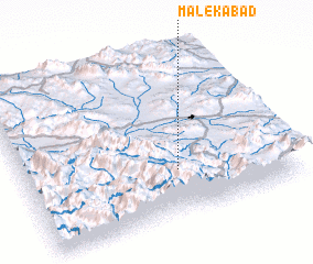 Places with similar names to Malekābād, Iran ::
Disclaimer :: Information on this page comes without warranty of any kind |
||
|
Where is Malekābād? Elevation and coordinates ::
Latitude (lat): 33°16'32"N Longitude (lon): 49°35'2"E
Elevation (approx.): 2147m (map arrows pan, magnifying glasses zoom) |
||
|
Visiting Malekābād? Hotel/Accommodation ::
Book a hotel in Malekābād Travel Guide ::
Buy a travel guide for Iran rental cars ::
car rental offers GPS waypoint ::
download a GPX waypoint (PoI) of Malekābād for your GPS receiver
|
||