|
search place name
|
||
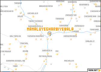
Māmālū-ye Gharbī-ye Bālā (Tehrān, Iran)Māmālū-ye Gharbī-ye Bālā is a town in the Tehrān region of Iran. An overview map of the region around Māmālū-ye Gharbī-ye Bālā is displayed below.
regional and 3d topo map of Māmālū-ye Gharbī-ye Bālā, Iran ::
Māmālū-ye Gharbī-ye Bālā airports ::
The nearest airport is THR - Teheran Mehrabad Intl, located 44.8 km west of Māmālū-ye Gharbī-ye Bālā.
Other airports nearby include RZR - Ramsar (175.8 km north west), Nearby towns ::
Palang Vār-e Bālā (0.4km north west) //
Yūrdeshāh-e Bālā (1.2km south) //
Yūrdeshāh (1.4km south west) //
Palangvāz-e Pā'īn (3.0km north east) //
Kamar Zar (3.0km west) //
Māmālū-ye Sharqī-ye Pā'īn (3.2km west) //
Khūkdānī (3.8km north west) //
Sīāh Sang (4.5km north east) //
Yūrdeshāh-e Pā'īn (4.6km west) //
Sīāh Sang (5.0km north east) //
Shekar Beyglū (5.1km north west) //
Tamāshā (6.1km north east) //
Darvāzeh (6.6km south) //
Takht Yāramīn (6.2km north west) //
Nīk (7.0km south) //
Kord-e Nabard (6.2km east) //
Neyak-e Jadīd (8.7km south) //
Kachalīūn (9.0km north west) //
Zardestān (9.2km north east) //
[all distances 'as the bird flies' and approximate]  Places with similar names to Māmālū-ye Gharbī-ye Bālā, Iran :: Disclaimer :: Information on this page comes without warranty of any kind |
||
|
Where is Māmālū-ye Gharbī-ye Bālā? Elevation and coordinates ::
Latitude (lat): 35°36'39"N Longitude (lon): 51°47'56"E
Elevation (approx.): 1285m (map arrows pan, magnifying glasses zoom) |
||
|
Visiting Māmālū-ye Gharbī-ye Bālā? Hotel/Accommodation ::
Book a hotel in Māmālū-ye Gharbī-ye Bālā Travel Guide ::
Buy a travel guide for Iran rental cars ::
car rental offers GPS waypoint ::
download a GPX waypoint (PoI) of Māmālū-ye Gharbī-ye Bālā for your GPS receiver
|
||