|
search place name
|
||
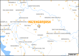
Māzeh Garqash (Khūzestān, Iran)Māzeh Garqash is a town in the Khūzestān region of Iran. An overview map of the region around Māzeh Garqash is displayed below.
regional and 3d topo map of Māzeh Garqash, Iran ::
Māzeh Garqash airports ::
The nearest airport is QMJ - Masjed Soleiman Shahid Asyaee, located 30.5 km east of Māzeh Garqash.
Other airports nearby include AWZ - Ahwaz (79.2 km south), MRX - Bandar Mahshahr Mahshahr (164.9 km south), ABD - Abadan (196.7 km south), BSR - Basrah Intl (205.2 km south west), Nearby towns ::
Garrāb (2.4km south west) //
Garmāb (2.4km south west) //
Jījīl (2.4km south west) //
Takht-e Āzādī (2.4km north west) //
Parchestān (3.6km south east) //
Chāl Barāftāb (3.6km north west) //
Pīr Gārī (4.6km south) //
Chahār Bīsheh (4.9km south east) //
Tak Takū (4.7km west) //
Kūh-e Zard (5.6km north) //
Māhūr-e Chāh Toranjī (6.6km north east) //
Parchestān-e Āl-e Kalī (6.6km east) //
Shīrkeshān (7.3km north west) //
Panj Mīlī (8.8km south east) //
Cham Konār (8.5km south west) //
Shalīlī-ye Kūchek (9.5km south west) //
Shalīlī-ye Kūchek (9.5km south west) //
Shalīlī-ye Kūchek (9.5km south west) //
[all distances 'as the bird flies' and approximate]  Places with similar names to Māzeh Garqash, Iran :: Disclaimer :: Information on this page comes without warranty of any kind |
||
|
Where is Māzeh Garqash? Elevation and coordinates ::
Latitude (lat): 32°2'0"N Longitude (lon): 48°57'0"E
Elevation (approx.): 151m (map arrows pan, magnifying glasses zoom) |
||
|
Visiting Māzeh Garqash? Hotel/Accommodation ::
Book a hotel in Māzeh Garqash Travel Guide ::
Buy a travel guide for Iran rental cars ::
car rental offers GPS waypoint ::
download a GPX waypoint (PoI) of Māzeh Garqash for your GPS receiver
|
||