|
search place name
|
||
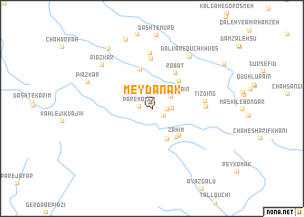
Meydānak (Fārs, Iran)Meydānak is a town in the Fārs region of Iran. An overview map of the region around Meydānak is displayed below.
regional and 3d topo map of Meydānak, Iran ::
Meydānak airports ::
The nearest airport is BUZ - Bushehr, located 125.5 km south of Meydānak.
Other airports nearby include SYZ - Shiraz Shahid Dastghaib Intl (139.9 km east), QMJ - Masjed Soleiman Shahid Asyaee (290.2 km north west), Nearby towns ::
Seh Bardeh (1.5km south east) //
Par-e Mollā (1.5km west) //
Hezār Darreh (1.6km east) //
Qal‘eh-ye Fatḩollāh (2.1km east) //
Tīzdīng-e Pā'īn (2.5km north east) //
Shahrenjān (4.0km south east) //
Zaḩīm (4.3km south east) //
Beshārgān (4.4km south east) //
‘Alīvarz (4.5km north east) //
Navān (5.0km north) //
Robāţ (5.1km north east) //
Qūch Khvos (6.2km north) //
Tīzdīng (5.7km east) //
Tīzdīng-e Bālā (5.8km east) //
Bībī Ḩannā (6.9km north) //
Dalvār-e Qūch Khvos (7.6km north east) //
Pīāz Kār (7.6km north west) //
Pīāz Kār (7.7km north west) //
Dasht-e Mūrd (9.0km north) //
Bābā Monīr (8.8km north west) //
[all distances 'as the bird flies' and approximate]  Places with similar names to Meydānak, Iran ::
Disclaimer :: Information on this page comes without warranty of any kind |
||
|
Where is Meydānak? Elevation and coordinates ::
Latitude (lat): 30°1'0"N Longitude (lon): 51°15'0"E
Elevation (approx.): 1196m (map arrows pan, magnifying glasses zoom) |
||
|
Visiting Meydānak? Hotel/Accommodation ::
Book a hotel in Meydānak Travel Guide ::
Buy a travel guide for Iran rental cars ::
car rental offers GPS waypoint ::
download a GPX waypoint (PoI) of Meydānak for your GPS receiver
|
||