|
search place name
|
||
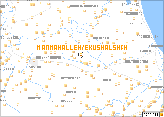
Mīān Maḩalleh-ye Kūshālshāh (Gīlān, Iran)Mīān Maḩalleh-ye Kūshālshāh is a town in the Gīlān region of Iran. An overview map of the region around Mīān Maḩalleh-ye Kūshālshāh is displayed below.
regional and 3d topo map of Mīān Maḩalleh-ye Kūshālshāh, Iran ::
Mīān Maḩalleh-ye Kūshālshāh airports ::
The nearest airport is RAS - Rasht, located 45.5 km west of Mīān Maḩalleh-ye Kūshālshāh.
Other airports nearby include RZR - Ramsar (61.7 km south east), THR - Teheran Mehrabad Intl (201.2 km south east), Nearby towns ::
Ākhūnd Maḩalleh (0.7km south) //
Bālā Maḩalleh-ye Kūshāl Shāh (1.2km south east) //
Dīzbon (1.3km south east) //
Sīāh Kaldeh (1.4km south east) //
Kūchekdeh (1.4km west) //
Sādāt Maḩalleh-ye Kūshāl Shāh (1.7km south east) //
Sādāt Maḩalleh (1.7km south east) //
Emām Deh (2.4km north) //
Khāleh Kūl (2.0km west) //
Pā'īn Maḩalleh-ye Nālkīāshar (2.3km north west) //
Gāchehvar (2.6km north) //
Tūt Bāgh Maḩalleh (2.2km west) //
Darvīshāneh Bar (2.4km south east) //
Ţālesh Maḩalleh (2.8km south) //
Arbāstān-e Bālā (3.4km north) //
Lūkolāyeh (3.5km south) //
Līālestān (3.1km south west) //
Rajab Maḩalleh-ye Nālkīāshar (3.3km north east) //
Bālā Maḩalleh-ye Nālkīāshar (3.4km north east) //
Ḩājjī Barandeh (3.2km south east) //
Ḩājjī Bāqer Maḩalleh (3.9km north) //
Kharrāţ Maḩalleh (3.4km south east) //
Arbāstān-e Pā'īn (4.3km north) //
Dīvshal (4.2km south east) //
Sīāh Gūrāb-e Pā'īn (4.2km north west) //
Yūsef Deh (4.6km north west) //
Dīvshal Poshteh (4.9km south east) //
Kūshāl (4.5km north west) //
Shīrjū Posht-e Pā'īn Maḩalleh (5.4km north) //
[all distances 'as the bird flies' and approximate]  Places with similar names to Mīān Maḩalleh-ye Kūshālshāh, Iran :: Disclaimer :: Information on this page comes without warranty of any kind |
||
|
Where is Mīān Maḩalleh-ye Kūshālshāh? Elevation and coordinates ::
Latitude (lat): 37°12'51"N Longitude (lon): 50°5'58"E
Elevation (approx.): -24m (map arrows pan, magnifying glasses zoom) |
||
|
Visiting Mīān Maḩalleh-ye Kūshālshāh? Hotel/Accommodation ::
Book a hotel in Mīān Maḩalleh-ye Kūshālshāh Travel Guide ::
Buy a travel guide for Iran rental cars ::
car rental offers GPS waypoint ::
download a GPX waypoint (PoI) of Mīān Maḩalleh-ye Kūshālshāh for your GPS receiver
|
||