|
search place name
|
||
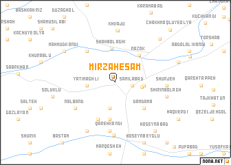
Mīrzā Ḩesām (Ostān-e Āz̄arbāyjān-e Sharqī, Iran)Mīrzā Ḩesām is a town in the Ostān-e Āz̄arbāyjān-e Sharqī region of Iran. An overview map of the region around Mīrzā Ḩesām is displayed below.
regional and 3d topo map of Mīrzā Ḩesām, Iran ::
Mīrzā Ḩesām airports ::
The nearest airport is TBZ - Tabriz Intl, located 140.5 km south east of Mīrzā Ḩesām.
Other airports nearby include VAN - Van (157.4 km west), Nearby towns ::
Sāmīlābād (2.2km east) //
Kamālābād (2.2km east) //
Shūrcheh-ye Ḩoseynābād (4.2km south) //
Kharmam Kand (3.4km east) //
Shīr Moḩammad (3.6km east) //
Yatīm Āghlī (3.7km west) //
Shāh Bolāghī (5.5km north) //
Nāzok (5.3km north east) //
Qanāt-e Bāqer Beyk (6.1km south) //
Dāmdāmā (5.5km south east) //
Qarah Kandī (6.4km south) //
Īlbolāghī (6.3km north west) //
Na‘lband (6.6km south west) //
Qameshgān-e Pā'īn (6.6km south west) //
Qareh Kandī (7.9km south) //
Shūrjeh (6.5km east) //
Khvājū (8.4km north) //
Gīvān (8.4km north) //
Qareh Ẕīā' od Dīn (8.6km south) //
Shīrīn Bolāgh (6.9km east) //
Chūmarān (8.7km south west) //
Kasīān (8.7km south west) //
Maḩmūd Kandī (8.3km north west) //
Chakhmāqlū'ī-ye Soflá (9.0km north east) //
Ḩoseynābād (9.3km south east) //
Chakhmāqlū-ye ‘Olyā (10.9km north east) //
[all distances 'as the bird flies' and approximate] 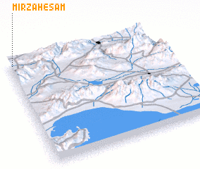 Places with similar names to Mīrzā Ḩesām, Iran :: Disclaimer :: Information on this page comes without warranty of any kind |
||
|
Where is Mīrzā Ḩesām? Elevation and coordinates ::
Latitude (lat): 38°58'15"N Longitude (lon): 45°1'31"E
Elevation (approx.): 1233m (map arrows pan, magnifying glasses zoom) |
||
|
Visiting Mīrzā Ḩesām? Hotel/Accommodation ::
Book a hotel in Mīrzā Ḩesām Travel Guide ::
Buy a travel guide for Iran rental cars ::
car rental offers GPS waypoint ::
download a GPX waypoint (PoI) of Mīrzā Ḩesām for your GPS receiver
|
||