|
search place name
|
||
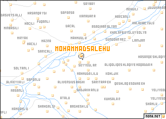
Moḩammad Şāleḩū (Iran)Moḩammad Şāleḩū is a town in Iran. An overview map of the region around Moḩammad Şāleḩū is displayed below.
regional and 3d topo map of Moḩammad Şāleḩū, Iran ::
Moḩammad Şāleḩū airports ::
The nearest airport is TBZ - Tabriz Intl, located 151.9 km south west of Moḩammad Şāleḩū.
Nearby towns ::
Gūzī ‘Alī (0.8km south west) //
Amīrāhlū (0.8km south west) //
Kāsehlar-e Bālā (1.1km south east) //
Qarīyeh Qeshlāq-e Homāylū (1.1km south east) //
Parvīz Khānlū (1.4km north west) //
Ḩasratān (2.1km south west) //
Seyyedlar (2.6km south) //
Qūyjāyq Bozorg (2.7km west) //
Aḩmadlū-ye ‘Olyā (3.1km south west) //
Mahmudlu (3.8km north) //
Qūyjāq-e Bālā (3.2km west) //
Şükürbǝyli (4.0km north west) //
‘Annāblū (4.3km south) //
Ūsowblū (4.4km south) //
Maḩmūd ‘Alīlū (4.4km south) //
Sharfeh (3.5km west) //
Moḩammadlū (4.2km south west) //
Aḩmadlū-ye Soflá (4.2km south west) //
Shīrlū (4.9km south east) //
Yuxarı Maralyan (5.1km north east) //
Cǝfǝrabad (5.7km north) //
Qārlūjeh (4.9km north east) //
Shykhaliagaly (4.9km north west) //
Sārī Beyglū (6.2km south) //
‘Alī Verdī Ūshāghī (6.5km south) //
Karkhulu (6.5km north) //
Dǝcǝl (6.7km north) //
Kadkhodālū-ye ‘Olyā (5.8km south west) //
Sārī Beyglū-ye Kūchak (7.4km south) //
[all distances 'as the bird flies' and approximate]  Places with similar names to Moḩammad Şāleḩū, Iran ::
// Moḩammad Şāleḩī (IR)
Disclaimer :: Information on this page comes without warranty of any kind |
||
|
Where is Moḩammad Şāleḩū? Elevation and coordinates ::
Latitude (lat): 39°17'19"N Longitude (lon): 47°10'23"E
Elevation (approx.): 255m (map arrows pan, magnifying glasses zoom) |
||
|
Visiting Moḩammad Şāleḩū? Hotel/Accommodation ::
Book a hotel in Moḩammad Şāleḩū Travel Guide ::
Buy a travel guide for Iran rental cars ::
car rental offers GPS waypoint ::
download a GPX waypoint (PoI) of Moḩammad Şāleḩū for your GPS receiver
|
||