|
search place name
|
||
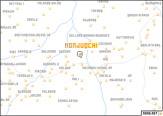
Monjūqchī (Ardabīl, Iran)Monjūqchī is a town in the Ardabīl region of Iran. An overview map of the region around Monjūqchī is displayed below.
regional and 3d topo map of Monjūqchī, Iran ::
Monjūqchī airports ::
The nearest airport is TBZ - Tabriz Intl, located 117.3 km west of Monjūqchī.
Nearby towns ::
Ḩabashī (1.5km south) //
Khanjar (2.1km south west) //
Aḩmad Beyglū (2.4km north east) //
Qoşābeh (2.6km west) //
Gūzdak (2.9km west) //
Kharāvān (3.7km south east) //
Mazra‘eh-ye Jahān (3.2km south west) //
Sāvojbolāgh (3.2km south west) //
Gellar-e Moḩammadḩasan (4.3km north) //
Bāllūqīyeh (4.3km south) //
Khvorshīdābād (4.5km south east) //
Kalhūr (4.4km south west) //
Ālūch (4.5km south east) //
Mazra‘eh-ye Khalaf (4.5km south east) //
Jamālābād (5.2km south) //
Bolūs (5.2km south) //
Dībaglū (5.2km south) //
Sha‘bān (4.8km south west) //
Dakesh (4.4km east) //
Ḩīq (4.7km east) //
Aḩmadābād (5.1km south east) //
Zīr Zamīn (4.9km north east) //
Malī (6.0km south) //
Dīglū (7.1km south) //
Andazaq (6.6km south east) //
Dūshānlū (6.0km south west) //
Ahl-e Īmān (5.8km west) //
Ḩeşār (6.8km south east) //
Sāchlū (6.8km south east) //
[all distances 'as the bird flies' and approximate] 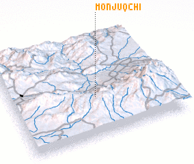 Places with similar names to Monjūqchī, Iran ::
// Māngi Kach (PK)
Disclaimer :: Information on this page comes without warranty of any kind |
||
|
Where is Monjūqchī? Elevation and coordinates ::
Latitude (lat): 38°23'49"N Longitude (lon): 47°31'58"E
Elevation (approx.): 1111m (map arrows pan, magnifying glasses zoom) |
||
|
Visiting Monjūqchī? Hotel/Accommodation ::
Book a hotel in Monjūqchī Travel Guide ::
Buy a travel guide for Iran rental cars ::
car rental offers GPS waypoint ::
download a GPX waypoint (PoI) of Monjūqchī for your GPS receiver
|
||