|
search place name
|
||
Naşīrābād (Khorāsān, Iran)Naşīrābād is a town in the Khorāsān region of Iran. An overview map of the region around Naşīrābād is displayed below.
regional and 3d topo map of Naşīrābād, Iran ::
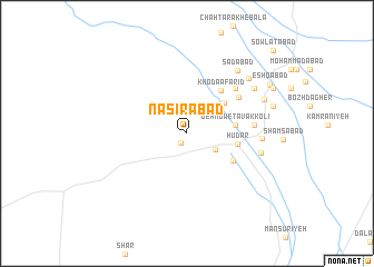
Nearby towns ::
Ebrāhīmābād (1.1km south west) //
Vakīlābād (2.9km south east) //
‘Abbāsābād (4.4km north east) //
Deh Now-e Tavakkolī (4.1km east) //
Hūdar (4.3km east) //
Moḩammadābād (4.7km south east) //
Khodā Āfarīd (5.2km north east) //
Taqīābād (5.6km north east) //
Raḩīmābād (6.1km north east) //
Aḩmadābād-e Kalāteh (5.7km east) //
Nūk (6.2km east) //
Dastgerdān (6.4km east) //
Sa‘dābād (7.6km north east) //
Karīmābād (7.2km north east) //
Ghanīābād (7.2km north east) //
Shāhābād (7.6km north east) //
Mīānābād (7.2km north east) //
Ḩasanābād (7.6km east) //
‘Eshqābād (8.4km north east) //
Zīrakābād (8.5km north east) //
Ḩājjīābād (8.5km north east) //
Nejātābād (8.5km north east) //
Şowlatābād (10.9km north east) //
[all distances 'as the bird flies' and approximate] 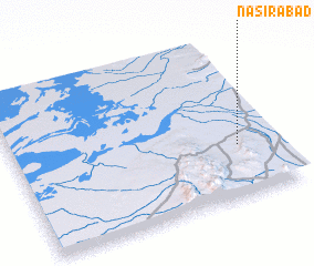 Places with similar names to Naşīrābād, Iran ::
Disclaimer :: Information on this page comes without warranty of any kind |
||
|
Where is Naşīrābād? Elevation and coordinates ::
Latitude (lat): 34°19'32"N Longitude (lon): 56°51'21"E
Elevation (approx.): 773m (map arrows pan, magnifying glasses zoom) |
||
|
Visiting Naşīrābād? Hotel/Accommodation ::
Book a hotel in Naşīrābād Travel Guide ::
Buy a travel guide for Iran rental cars ::
car rental offers GPS waypoint ::
download a GPX waypoint (PoI) of Naşīrābād for your GPS receiver
|
||