|
search place name
|
||
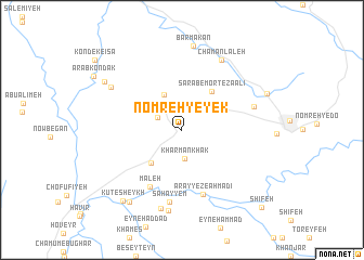
Nomreh-ye Yek (Khūzestān, Iran)Nomreh-ye Yek is a town in the Khūzestān region of Iran. An overview map of the region around Nomreh-ye Yek is displayed below.
regional and 3d topo map of Nomreh-ye Yek, Iran ::
Nomreh-ye Yek airports ::
The nearest airport is AWZ - Ahwaz, located 64.6 km west of Nomreh-ye Yek.
Other airports nearby include QMJ - Masjed Soleiman Shahid Asyaee (64.9 km north), MRX - Bandar Mahshahr Mahshahr (100.9 km south), ABD - Abadan (164.7 km south west), BSR - Basrah Intl (195.4 km south west), Nearby towns ::
Emām Şafī-ye Now (2.5km north west) //
Kharman Khāk (3.0km south) //
Emām Şafī (4.0km north west) //
Boneh-ye Khanjar (4.4km south west) //
Sarāb-e Morteẕá ‘Alī (4.8km north east) //
Māleḩ (6.5km south west) //
‘Arayyeẕ-e Aḩmadī (6.9km south) //
Sahayyem (7.5km south) //
Darvāzeh (6.8km east) //
Chaman Lāleh (8.0km north east) //
Talgasar-e Pāʼīn (8.3km south) //
Tall Gesar (8.4km south) //
Sarāj od Dīn (7.6km north west) //
Barmakān (8.7km north) //
Āb Deh Vīs (8.8km south west) //
Kondok Sarāyeddīn (8.4km north west) //
Barm-e Gāvmīshī ‘Olyā (8.3km north east) //
Kūt-e Sheykh (9.0km south west) //
Shīfeh (10.6km south east) //
[all distances 'as the bird flies' and approximate] 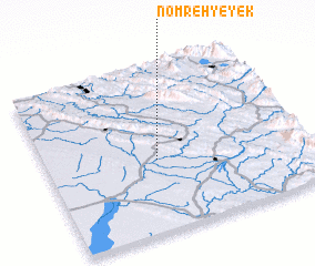 Places with similar names to Nomreh-ye Yek, Iran :: Disclaimer :: Information on this page comes without warranty of any kind |
||
|
Where is Nomreh-ye Yek? Elevation and coordinates ::
Latitude (lat): 31°26'1"N Longitude (lon): 49°25'55"E
Elevation (approx.): 80m (map arrows pan, magnifying glasses zoom) |
||
|
Visiting Nomreh-ye Yek? Hotel/Accommodation ::
Book a hotel in Nomreh-ye Yek Travel Guide ::
Buy a travel guide for Iran rental cars ::
car rental offers GPS waypoint ::
download a GPX waypoint (PoI) of Nomreh-ye Yek for your GPS receiver
|
||