|
search place name
|
||
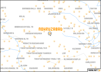
Nowrūzābād (Ostān-e Kermānshāh, Iran)Nowrūzābād is a town in the Ostān-e Kermānshāh region of Iran. An overview map of the region around Nowrūzābād is displayed below.
regional and 3d topo map of Nowrūzābād, Iran ::
Nowrūzābād airports ::
The nearest airport is KSH - Bakhtaran Shahid Ashrafi Esfahani, located 65.7 km east of Nowrūzābād.
Other airports nearby include SDG - Sanandaj (90.6 km north east), Nearby towns ::
Naz̧argāh (2.3km south east) //
Deh Sorkh (2.6km north west) //
Kerkereh (3.9km south) //
Bolhavāz (4.3km south east) //
Pel Havās (4.7km south east) //
Nīlāvareh-ye ‘Olyā (4.5km north east) //
Kanūleh-ye Jūzū (5.2km north east) //
Maleh Amīrkhān (4.8km west) //
Vandeh Rangīneh (5.0km west) //
Kanūleh-ye Bālā (6.0km north east) //
Qal‘eh-ye Soleymān Khān (5.7km south east) //
Haft Cheshmeh (6.6km south) //
Posht Tang-e Shāhmār (6.3km south west) //
Tāzehābād-e Shāhmār-e Bābāmorād (6.3km south west) //
Jājān-e Bālā (7.2km north) //
Haftkadeh (6.6km south east) //
Jājān (7.4km north) //
Shaleh-ye Bālā (6.7km north east) //
Bābā Kūseh-ye Soflá (6.7km west) //
Takhtgāh-e Dānīāl (7.9km south west) //
Takhtgāh-e Şafīyār Solţān (7.6km south west) //
Nowrūleh-ye ‘Olyā (7.9km north east) //
Rūtevān (7.9km north east) //
Takhtgāh-e Şūrat Khānom (8.3km south west) //
Shāhmār-e Bābā Morād (7.6km south west) //
Shāhmār-e Mīrzā Morād (7.6km south west) //
Cheshmeh Sefīd (8.0km south west) //
Kandūleh (8.4km north east) //
Kordvand (7.4km east) //
[all distances 'as the bird flies' and approximate]  Places with similar names to Nowrūzābād, Iran ::
// Nauruz-Abad (TM)
// Nowrūzābād (IR)
// Nowrūzābād (IR)
// Nowrūzābād (IR)
// Nowrūzābād (IR)
// Nowrūzābād (IR)
// Nowrūzābād (IR)
// Nowrūzābād (IR)
// Nowrūzābād (IR)
// Nowrūzābād (IR)
Disclaimer :: Information on this page comes without warranty of any kind |
||
|
Where is Nowrūzābād? Elevation and coordinates ::
Latitude (lat): 34°33'4"N Longitude (lon): 46°29'16"E
Elevation (approx.): 1575m (map arrows pan, magnifying glasses zoom) |
||
|
Visiting Nowrūzābād? Hotel/Accommodation ::
Book a hotel in Nowrūzābād Travel Guide ::
Buy a travel guide for Iran rental cars ::
car rental offers GPS waypoint ::
download a GPX waypoint (PoI) of Nowrūzābād for your GPS receiver
|
||