|
search place name
|
||
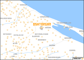
Oshtorgān (Gīlān, Iran)Oshtorgān is a town in the Gīlān region of Iran. An overview map of the region around Oshtorgān is displayed below.
regional and 3d topo map of Oshtorgān, Iran ::
Oshtorgān airports ::
The nearest airport is RAS - Rasht, located 39.5 km south east of Oshtorgān.
Other airports nearby include RZR - Ramsar (145.5 km south east), Nearby towns ::
Shīl-e Sar (1.2km north) //
Kargān (2.3km east) //
Sīāh Vazān (2.9km north) //
Bīstīn Gāleshhā (3.0km south) //
Sīāh Khālehsar (2.8km north east) //
Dahaneh Sar (3.5km north) //
Khalīl Maḩalleh (3.1km north west) //
Gālesh Khīl (3.2km west) //
Torbehbar (3.6km north west) //
Ḩarf-e Kām (3.4km west) //
Kechalak (4.1km north east) //
Feyẕollāh Maḩalleh (4.4km north) //
Dīnaj Maḩalleh (3.6km west) //
Bījār Kan (4.4km south west) //
‘Alīābād-e Kapūrchāl (4.6km north east) //
Chāy Bījār (4.9km north) //
Kapūrchāl (4.8km north) //
Khomīrān (4.0km east) //
Māzandarān Maḩalleh-ye Bahambar (5.5km south) //
Bahambar (5.5km south) //
Dārsarā (5.0km north west) //
Jīrsar-e Nowdeh (5.5km south) //
Dīlaj Maḩalleh (4.7km west) //
Rūdposht (5.8km north) //
Kachalak Maḩalleh (5.0km north east) //
Bodāgh Maḩalleh (5.6km north west) //
Dār Sarā (5.4km north west) //
Sīāhbīl (5.1km west) //
Ma‘āf (5.4km south east) //
[all distances 'as the bird flies' and approximate]  Places with similar names to Oshtorgān, Iran :: Disclaimer :: Information on this page comes without warranty of any kind |
||
|
Where is Oshtorgān? Elevation and coordinates ::
Latitude (lat): 37°29'51"N Longitude (lon): 49°12'54"E
Elevation (approx.): -8m (map arrows pan, magnifying glasses zoom) |
||
|
Visiting Oshtorgān? Hotel/Accommodation ::
Book a hotel in Oshtorgān Travel Guide ::
Buy a travel guide for Iran rental cars ::
car rental offers GPS waypoint ::
download a GPX waypoint (PoI) of Oshtorgān for your GPS receiver
|
||