|
search place name
|
||
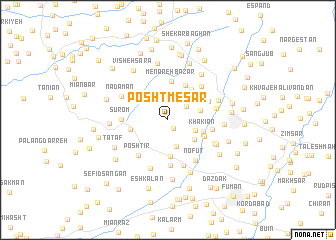
Posht Mesār (Gīlān, Iran)Posht Mesār is a town in the Gīlān region of Iran. An overview map of the region around Posht Mesār is displayed below.
regional and 3d topo map of Posht Mesār, Iran ::
Posht Mesār airports ::
The nearest airport is RAS - Rasht, located 32.0 km east of Posht Mesār.
Other airports nearby include RZR - Ramsar (134.6 km east), Nearby towns ::
Markīyeh (1.1km south east) //
Pāsgeh (2.2km north east) //
Pā'īn Bowlgūr (2.6km north east) //
Sehshanbeh (3.1km south) //
Pardeh Sar (3.2km north) //
Bālā Bowlgūr (2.7km south east) //
Komā' (3.2km south east) //
Kherf (3.0km east) //
Pīr Sarā (3.3km north west) //
Sīāh Esţalkh (4.1km south) //
Jīrgūrāb (3.8km north east) //
Khākīān (3.4km east) //
Shāram (4.0km north east) //
Menāreh Bāzār (4.3km north) //
Gūrāb Zarmakh (3.5km west) //
Pūstīn Sarā (4.2km north) //
Bāgh Dasht (3.8km south east) //
Kasmā' (4.2km north east) //
Lādmakh (4.1km east) //
Naşrollāhābād (5.1km south) //
Sūrom (4.1km west) //
Poshtīr (4.8km south west) //
Za‘fān (4.8km north east) //
Otowr Sarā (5.3km south) //
Nofūt (5.2km south east) //
Qaşşāb Sarā (4.5km east) //
Māvardīān (4.9km south east) //
Komā Mardakh (5.7km south) //
Nadāmān (4.9km north west) //
[all distances 'as the bird flies' and approximate]  Places with similar names to Posht Mesār, Iran ::
// Posht-e Mazār (AF)
Disclaimer :: Information on this page comes without warranty of any kind |
||
|
Where is Posht Mesār? Elevation and coordinates ::
Latitude (lat): 37°18'1"N Longitude (lon): 49°14'47"E
Elevation (approx.): 14m (map arrows pan, magnifying glasses zoom) |
||
|
Visiting Posht Mesār? Hotel/Accommodation ::
Book a hotel in Posht Mesār Travel Guide ::
Buy a travel guide for Iran rental cars ::
car rental offers GPS waypoint ::
download a GPX waypoint (PoI) of Posht Mesār for your GPS receiver
|
||