|
search place name
|
||
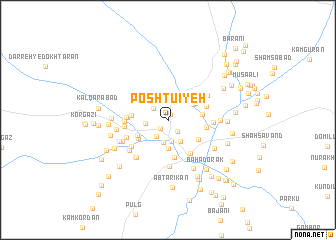
Poshtū'īyeh (Hormozgān, Iran)Poshtū'īyeh is a town in the Hormozgān region of Iran. An overview map of the region around Poshtū'īyeh is displayed below.
regional and 3d topo map of Poshtū'īyeh, Iran ::
Poshtū'īyeh airports ::
The nearest airport is BND - Bandar Abbass Intl, located 103.3 km south west of Poshtū'īyeh.
Other airports nearby include KHS - Khasab (203.5 km south west), Nearby towns ::
Aḩmadābād-e Poshtū'īyeh (0.6km north) //
‘Alīābād (1.2km south west) //
‘Azīzābād (1.6km south east) //
‘Abbāsābād (1.9km north west) //
Sa‘īdābād (2.1km south west) //
Dahīrī (2.4km south) //
Pīmejān (2.5km south) //
Ḩājjīābād (2.3km west) //
Mosāferābād (2.5km north east) //
Mardābād (2.7km south east) //
Mīrābād (3.2km south) //
Qanbarābād (3.0km north east) //
Rostamābād (3.2km north east) //
Sargost-e Pā'īn (3.5km south west) //
Qal‘eh-ye Moz̧afarābād (3.4km east) //
Maryamābād (3.6km north east) //
Kondar (3.6km south west) //
Pākam-e Pā'īn (3.6km west) //
Qal‘eh Dezh (3.6km west) //
Sang Sefīd (3.8km south east) //
Sar Korūkān (4.2km south) //
Ḩoseynābād (3.9km east) //
Aḩmadābād (4.3km south east) //
Mīān Chīlān (4.1km east) //
Pākam-e Bālā (4.1km west) //
Sarzeh (4.1km west) //
Sarkahnān (4.3km west) //
Qalamān (4.3km west) //
Ebrāhīm ‘Alī (4.5km south west) //
[all distances 'as the bird flies' and approximate] 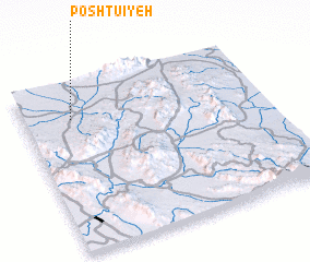 Places with similar names to Poshtū'īyeh, Iran :: Disclaimer :: Information on this page comes without warranty of any kind |
||
|
Where is Poshtū'īyeh? Elevation and coordinates ::
Latitude (lat): 27°47'41"N Longitude (lon): 57°11'57"E
Elevation (approx.): 487m (map arrows pan, magnifying glasses zoom) |
||
|
Visiting Poshtū'īyeh? Hotel/Accommodation ::
Book a hotel in Poshtū'īyeh Travel Guide ::
Buy a travel guide for Iran rental cars ::
car rental offers GPS waypoint ::
download a GPX waypoint (PoI) of Poshtū'īyeh for your GPS receiver
|
||