|
search place name
|
||
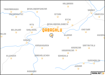
Qabāghlū (Kordestān, Iran)Qabāghlū is a town in the Kordestān region of Iran. An overview map of the region around Qabāghlū is displayed below.
regional and 3d topo map of Qabāghlū, Iran ::
Qabāghlū airports ::
The nearest airport is SDG - Sanandaj, located 128.4 km south east of Qabāghlū.
Other airports nearby include TBZ - Tabriz Intl (218.5 km north), KSH - Bakhtaran Shahid Ashrafi Esfahani (221.9 km south east), Nearby towns ::
Qeshlāq-e Şāleḩ Beyk (4.0km north) //
Kandeh Sūreh (4.8km south west) //
Hījānān (4.5km east) //
Īstgāh (7.6km north) //
Shālī Shal (6.3km west) //
Kasan Nazān (7.1km south east) //
Āychī (7.1km north east) //
Qabgholūcheh (8.0km south) //
Mītū (7.0km north west) //
Somāghlū (8.0km south) //
‘Alīābād (7.2km north east) //
Kas Nazān (8.2km south east) //
[all distances 'as the bird flies' and approximate]  Places with similar names to Qabāghlū, Iran ::
// Cobbville (US)
// Caba Vale (ZA)
// Cobbville (US)
// Kibbeville (US)
// Gueb Fal (SN)
// Gbafala (GN)
// Guibeville (FR)
// Cabvula (MW)
// Kabvala (MW)
// Gouabafla (CI)
Disclaimer :: Information on this page comes without warranty of any kind |
||
|
Where is Qabāghlū? Elevation and coordinates ::
Latitude (lat): 36°10'0"N Longitude (lon): 46°9'0"E
Elevation (approx.): 1711m (map arrows pan, magnifying glasses zoom) |
||
|
Visiting Qabāghlū? Hotel/Accommodation ::
Book a hotel in Qabāghlū Travel Guide ::
Buy a travel guide for Iran rental cars ::
car rental offers GPS waypoint ::
download a GPX waypoint (PoI) of Qabāghlū for your GPS receiver
|
||