|
search place name
|
||
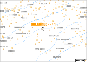
Qal‘eh Rūdkhān (Gīlān, Iran)Qal‘eh Rūdkhān is a town in the Gīlān region of Iran. An overview map of the region around Qal‘eh Rūdkhān is displayed below.
regional and 3d topo map of Qal‘eh Rūdkhān, Iran ::
Qal‘eh Rūdkhān airports ::
The nearest airport is RAS - Rasht, located 41.0 km north east of Qal‘eh Rūdkhān.
Other airports nearby include RZR - Ramsar (129.2 km east), Nearby towns ::
Tang Darreh (2.3km north) //
Seyyedābād (2.0km east) //
Shāvīzān (2.4km south west) //
Ḩeydar Ālāt (3.2km south west) //
Gasht-e Rūdkhān (3.3km north west) //
Pīr Sarā (3.6km north) //
Khāneh-ye Layeh Kandeh (3.9km south) //
Moleskām (3.4km north east) //
Seyyed Sarā (4.4km north) //
Taleh Kongāh (4.5km north) //
Fūsheh (4.6km north) //
Mīshkeh (4.4km south west) //
Khosrowābād (4.0km east) //
Seh Emāmzādeh (4.3km north west) //
Malekeh Sar (5.2km south) //
Lapavandān (5.3km south east) //
Sefīd Mazgī (5.0km south east) //
Shūlam (5.4km north west) //
Ḩallāj Maḩalleh (5.4km north east) //
Dārbāgh (6.0km north) //
Barī Bon (4.9km west) //
Sālek Mo‘allem (5.2km east) //
Gūrābpas (5.4km north east) //
Kīsh-e Rūdbār (6.5km north) //
Mīr ‘Alī Sarā (6.3km south west) //
Kord Maḩalleh (7.1km north) //
Ābrūd (6.8km north west) //
Shālmā (5.9km east) //
Deylam Bījār (8.3km north) //
[all distances 'as the bird flies' and approximate]  Places with similar names to Qal‘eh Rūdkhān, Iran :: Disclaimer :: Information on this page comes without warranty of any kind |
||
|
Where is Qal‘eh Rūdkhān? Elevation and coordinates ::
Latitude (lat): 37°5'39"N Longitude (lon): 49°14'45"E
Elevation (approx.): 446m (map arrows pan, magnifying glasses zoom) |
||
|
Visiting Qal‘eh Rūdkhān? Hotel/Accommodation ::
Book a hotel in Qal‘eh Rūdkhān Travel Guide ::
Buy a travel guide for Iran rental cars ::
car rental offers GPS waypoint ::
download a GPX waypoint (PoI) of Qal‘eh Rūdkhān for your GPS receiver
|
||