|
search place name
|
||
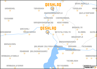
Qeshlāq (Ostān-e Āz̄arbāyjān-e Sharqī, Iran)Qeshlāq is a town in the Ostān-e Āz̄arbāyjān-e Sharqī region of Iran. An overview map of the region around Qeshlāq is displayed below.
regional and 3d topo map of Qeshlāq, Iran ::
Qeshlāq airports ::
The nearest airport is SDG - Sanandaj, located 141.3 km south of Qeshlāq.
Other airports nearby include TBZ - Tabriz Intl (188.4 km north), Nearby towns ::
Gol Charmū (1.5km east) //
Sārī Qomīsh-e Qeshlāq (4.0km north) //
Beygtūlī-ye ‘Olyā (4.5km east) //
Kerkereh (5.6km north) //
Zolfīneh (5.6km south) //
Ḩoseynābād (5.8km north east) //
Yamīnābād (6.3km south east) //
Qalandar (6.3km south west) //
Qāshoq (6.3km south east) //
Takān Tappeh (6.0km west) //
Mahmūdābād-e Soflá (7.6km north) //
Cherāgh Abdāl (7.1km north east) //
Bardeh Naqshīneh (7.0km south east) //
Qal‘ehgāh-e Gūdarz (8.0km south) //
Ḩasanābād-e Qāshoq (8.7km south east) //
[all distances 'as the bird flies' and approximate]  Places with similar names to Qeshlāq, Iran ::
// Cache Lake (US)
// Cache Lake (US)
// Kisiołki (PL)
// Kachulka (BG)
// Kashleyka (RU)
// Kocheleyka (RU)
// Kuchulga (RU)
// Kushelga (RU)
// Kushlega (RU)
// Qashlāq (IQ)
Disclaimer :: Information on this page comes without warranty of any kind |
||
|
Where is Qeshlāq? Elevation and coordinates ::
Latitude (lat): 36°27'0"N Longitude (lon): 46°30'0"E
Elevation (approx.): 1451m (map arrows pan, magnifying glasses zoom) |
||
|
Visiting Qeshlāq? Hotel/Accommodation ::
Book a hotel in Qeshlāq Travel Guide ::
Buy a travel guide for Iran rental cars ::
car rental offers GPS waypoint ::
download a GPX waypoint (PoI) of Qeshlāq for your GPS receiver
|
||