|
search place name
|
||
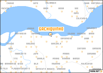
Gã Chiquinho (Guinea-Bissau)Gã Chiquinho is a town in Guinea-Bissau. An overview map of the region around Gã Chiquinho is displayed below.
regional and 3d topo map of Gã Chiquinho, Guinea-Bissau ::
Gã Chiquinho airports ::
The nearest airport is BXO - Bissau Oswaldo Vieira Intl, located 40.5 km west of Gã Chiquinho.
Other airports nearby include ZIG - Ziguinchor (132.7 km north west), CSK - Cap Skiring (170.2 km west), BJL - Banjul Intl (220.5 km north west), FIG - Fira Fria (251.4 km south east), Nearby towns ::
Ganduá Porto (1.8km east) //
Gã Chiquinho Mancanha (2.6km south east) //
Dodoco (2.6km south west) //
Galecunde (3.6km west) //
Ganduá Mandinga (4.1km south east) //
Sancorlá (4.1km south east) //
Áfià (5.2km south east) //
Gã Pedro (5.4km west) //
Jabadá Mancanha (5.4km west) //
Gã Formoso (5.7km east) //
Mantampa (6.6km south west) //
Gã João (7.3km east) //
Flaque Amedé (7.3km west) //
Jabadá (7.5km west) //
Flaque Cibe (7.5km west) //
Jabadá Beafada (7.6km south) //
Flaque Sunha (7.8km south west) //
Bária (8.3km south east) //
São José (8.1km south west) //
Jufá (9.2km south west) //
Prábis (9.2km south east) //
Blassé (10.4km north east) //
[all distances 'as the bird flies' and approximate]  Places with similar names to Gã Chiquinho, Guinea-Bissau ::
// Gã Chiquinho (GW)
Disclaimer :: Information on this page comes without warranty of any kind |
||
|
Where is Gã Chiquinho? Elevation and coordinates ::
Latitude (lat): 11°52'0"N Longitude (lon): 15°17'0"W
Elevation (approx.): 11m (map arrows pan, magnifying glasses zoom) |
||
|
Visiting Gã Chiquinho? Hotel/Accommodation ::
Book a hotel in Gã Chiquinho Travel Guide ::
rental cars ::
car rental offers GPS waypoint ::
download a GPX waypoint (PoI) of Gã Chiquinho for your GPS receiver
|
||