|
search place name
|
||
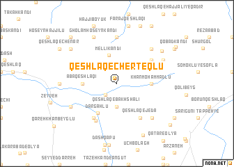
Qeshlāq-e Cherteqlū (Iran)Qeshlāq-e Cherteqlū is a town in Iran. An overview map of the region around Qeshlāq-e Cherteqlū is displayed below.
regional and 3d topo map of Qeshlāq-e Cherteqlū, Iran ::
Qeshlāq-e Cherteqlū airports ::
The nearest airport is TBZ - Tabriz Intl, located 173.5 km south west of Qeshlāq-e Cherteqlū.
Other airports nearby include RAS - Rasht (259.6 km south east), Nearby towns ::
‘Azīzollāh Qeshlāq (2.3km south west) //
Qeshlāq-e Bakhsh‘alī (3.7km south) //
Mellī Kandī (4.6km north) //
Khān Moḩammadlū (4.3km east) //
‘Abā Qeshlāqī (4.3km west) //
Dargāhlū (5.3km south west) //
Shā‘erlū (6.3km south west) //
Damīrch-ye Kharābahsī (5.7km north east) //
Qeshlāq-e Jedā (6.3km south east) //
Tūlāchī (6.6km south west) //
Qeshlāq-e Karpīchlū (7.4km north) //
Mīrverdī Kandī (7.0km north east) //
Jedā (7.1km south east) //
Qeshlāq-e ḨājjīPāpūr (6.8km south west) //
Qeshlāq-e Seyyedlar-e Seyfollāh (8.0km north) //
Qeshlāq-e Seyyedlar-e Mūsá (8.0km north) //
Tepelgā (6.8km north east) //
Gholām Ḩoseyn Kandī (8.0km north) //
Īdehlū (7.6km north east) //
Chenār (8.0km north west) //
Kūrāmālū (9.0km south) //
Ḩājjī Nowrūsh Kandī (9.4km north west) //
Narīmān (9.4km south east) //
[all distances 'as the bird flies' and approximate] 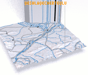 Places with similar names to Qeshlāq-e Cherteqlū, Iran :: Disclaimer :: Information on this page comes without warranty of any kind |
||
|
Where is Qeshlāq-e Cherteqlū? Elevation and coordinates ::
Latitude (lat): 39°9'0"N Longitude (lon): 47°45'0"E
Elevation (approx.): 637m (map arrows pan, magnifying glasses zoom) |
||
|
Visiting Qeshlāq-e Cherteqlū? Hotel/Accommodation ::
Book a hotel in Qeshlāq-e Cherteqlū Travel Guide ::
Buy a travel guide for Iran rental cars ::
car rental offers GPS waypoint ::
download a GPX waypoint (PoI) of Qeshlāq-e Cherteqlū for your GPS receiver
|
||