|
search place name
|
||
Qeshlāq-e Madadlū (Iran)Qeshlāq-e Madadlū is a town in Iran. An overview map of the region around Qeshlāq-e Madadlū is displayed below.
regional and 3d topo map of Qeshlāq-e Madadlū, Iran ::

Qeshlāq-e Madadlū airports ::
The nearest airport is TBZ - Tabriz Intl, located 163.2 km south west of Qeshlāq-e Madadlū.
Nearby towns ::
Ḩasan Qeshlāqī-ye Moqaddam (1.4km west) //
Āgh Qeshlāq (3.7km south) //
Qeshlāq-e Moqaddam (3.4km north east) //
Ayrī Būjāq Beyglū (4.0km north) //
Ḩasan Qeshlāqī-ye Kangarlū (4.0km south) //
‘Alī Qolī Qeshlāqī (6.3km south west) //
Lārījān (5.4km west) //
Halāk Beyglū (6.0km north west) //
Jūjūkh Marjānlī (7.6km north) //
Qolī Beyglū-ye ‘Olyā (7.6km north) //
Mazd Dahlar (8.0km north east) //
Çocuq Mǝrcanlı (9.4km north west) //
Mehdili (9.6km north west) //
[all distances 'as the bird flies' and approximate] 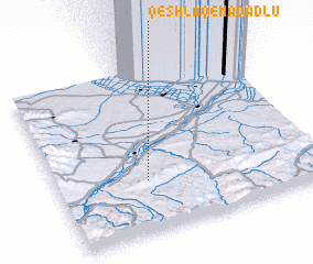 Places with similar names to Qeshlāq-e Madadlū, Iran :: Disclaimer :: Information on this page comes without warranty of any kind |
||
|
Where is Qeshlāq-e Madadlū? Elevation and coordinates ::
Latitude (lat): 39°19'0"N Longitude (lon): 47°21'0"E
Elevation (approx.): 326m (map arrows pan, magnifying glasses zoom) |
||
|
Visiting Qeshlāq-e Madadlū? Hotel/Accommodation ::
Book a hotel in Qeshlāq-e Madadlū Travel Guide ::
Buy a travel guide for Iran rental cars ::
car rental offers GPS waypoint ::
download a GPX waypoint (PoI) of Qeshlāq-e Madadlū for your GPS receiver
|
||