|
search place name
|
||
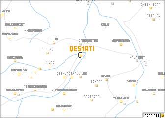
Qesmatī (Ostān-e Āz̄arbāyjān-e Sharqī, Iran)Qesmatī is a town in the Ostān-e Āz̄arbāyjān-e Sharqī region of Iran. An overview map of the region around Qesmatī is displayed below.
regional and 3d topo map of Qesmatī, Iran ::
Qesmatī airports ::
The nearest airport is TBZ - Tabriz Intl, located 56.0 km south of Qesmatī.
Nearby towns ::
Kabūd Gonbad (3.3km north) //
Qareh Qayah (3.4km north) //
Galv (4.2km south) //
Aljīlar (4.5km south west) //
Qeshlāq-e Ḩājjīlār (4.5km south west) //
Ḩājjīlar-e Gūnī (5.3km south west) //
Sohrān (6.5km south east) //
Bīshak (6.3km south east) //
Līlāb (6.3km north west) //
Mīlaq (6.0km west) //
Nechaq (6.3km west) //
Kalū (8.0km north east) //
Javānān-e Gorūh (8.5km south) //
Ja‘farābād (7.6km north east) //
[all distances 'as the bird flies' and approximate] 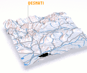 Places with similar names to Qesmatī, Iran ::
// Casamata (PH)
// Kismet (US)
// Kismet (US)
// Case Matte (IT)
// Csomád (HU)
// Kosmata (BG)
// Cuşmed (RO)
// Casa Matao (ES)
// Kismet (US)
// Kismat (BD)
Disclaimer :: Information on this page comes without warranty of any kind |
||
|
Where is Qesmatī? Elevation and coordinates ::
Latitude (lat): 38°38'15"N Longitude (lon): 46°16'15"E
Elevation (approx.): 1141m (map arrows pan, magnifying glasses zoom) |
||
|
Visiting Qesmatī? Hotel/Accommodation ::
Book a hotel in Qesmatī Travel Guide ::
Buy a travel guide for Iran rental cars ::
car rental offers GPS waypoint ::
download a GPX waypoint (PoI) of Qesmatī for your GPS receiver
|
||