|
search place name
|
||
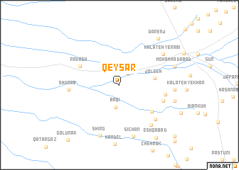
Qeyşār (Khorāsān, Iran)Qeyşār is a town in the Khorāsān region of Iran. An overview map of the region around Qeyşār is displayed below.
regional and 3d topo map of Qeyşār, Iran ::
Qeyşār airports ::
The nearest airport is XBJ - Birjand, located 45.0 km south of Qeyşār.
Nearby towns ::
Tappeh-ye Hezar Ḩīrī (2.1km north east) //
Baqī (3.5km south) //
Jolgeh (4.7km east) //
Kazeh Khārī (5.9km south east) //
Kalāteh-ye Nāyeb (5.9km south east) //
Rāvash (5.9km north west) //
Cheng Zard (6.3km south east) //
Kalāteh-ye Dallākān (6.2km east) //
Kalāteh-ye Shams-e Long (7.2km south east) //
Sar Dasht (7.5km south east) //
Shūrāb (6.7km west) //
Kalāteh-ye Rabī‘ (7.5km north east) //
Sīchān (8.3km south) //
Shīrg (8.4km south) //
Ḩasanābād (7.3km east) //
Aḩmadābād (7.7km east) //
Kalāteh-ye ‘Abbās (7.7km east) //
Moḩammadābād (7.8km east) //
Dārenj (8.9km north east) //
‘Eshqābād (9.6km south east) //
Golūnak (10.9km south west) //
Al Jūrak (10.9km south east) //
Rūshnāvand (11.4km south east) //
[all distances 'as the bird flies' and approximate]  Places with similar names to Qeyşār, Iran ::
Disclaimer :: Information on this page comes without warranty of any kind |
||
|
Where is Qeyşār? Elevation and coordinates ::
Latitude (lat): 33°17'23"N Longitude (lon): 59°8'19"E
Elevation (approx.): 1545m (map arrows pan, magnifying glasses zoom) |
||
|
Visiting Qeyşār? Hotel/Accommodation ::
Book a hotel in Qeyşār Travel Guide ::
Buy a travel guide for Iran rental cars ::
car rental offers GPS waypoint ::
download a GPX waypoint (PoI) of Qeyşār for your GPS receiver
|
||