|
search place name
|
||
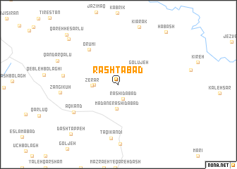
Rashtābād (Iran)Rashtābād is a town in Iran. An overview map of the region around Rashtābād is displayed below.
regional and 3d topo map of Rashtābād, Iran ::
Rashtābād airports ::
The nearest airport is RAS - Rasht, located 112.4 km east of Rashtābād.
Other airports nearby include SDG - Sanandaj (239.6 km south west), Nearby towns ::
Rashīdābād (2.4km south) //
Ma‘dan-e Rashīdābād (3.8km south) //
Kalhīn (3.1km west) //
Golūjeh (3.6km north east) //
Zerar (3.3km west) //
Orūmī (6.6km north west) //
Āqkand (7.2km south west) //
Taqī Kandī (8.6km south) //
Lahargīn (7.1km west) //
Qarasari (9.6km north west) //
Dāsh Tappeh (9.9km south west) //
Ḩabashī (10.3km north east) //
Ḩabash (10.3km north east) //
Qareh Ḩeşārlū (10.3km north west) //
[all distances 'as the bird flies' and approximate] 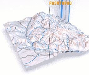 Places with similar names to Rashtābād, Iran ::
// Rashīdābād (IR)
// Rashīdābād (IR)
// Rashīdābād (IR)
// Rashīdābād (IR)
// Rashīdābād (IR)
// Rashīdābād (IR)
// Rashīdābād (IR)
// Rashīdābād (IR)
// Rashīdābād (IR)
// Rashīdābād (IR)
Disclaimer :: Information on this page comes without warranty of any kind |
||
|
Where is Rashtābād? Elevation and coordinates ::
Latitude (lat): 37°6'7"N Longitude (lon): 48°22'15"E
Elevation (approx.): 1661m (map arrows pan, magnifying glasses zoom) |
||
|
Visiting Rashtābād? Hotel/Accommodation ::
Book a hotel in Rashtābād Travel Guide ::
Buy a travel guide for Iran rental cars ::
car rental offers GPS waypoint ::
download a GPX waypoint (PoI) of Rashtābād for your GPS receiver
|
||