|
search place name
|
||
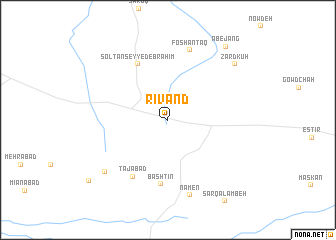
Rīvand (Khorāsān, Iran)Rīvand is a town in the Khorāsān region of Iran. An overview map of the region around Rīvand is displayed below.
regional and 3d topo map of Rīvand, Iran ::
Rīvand airports ::
The nearest airport is ASB - Ashkhabad Ashgabat, located 215.1 km north east of Rīvand.
Nearby towns ::
Solţān Seyyed Ebrāhīm (6.9km north west) //
Bāshtīn (7.2km south) //
Tājābād (7.1km south west) //
Foshantaq (8.0km north) //
Nāmen (8.6km south) //
Feyzābād (8.1km south west) //
Zard Kūh (8.7km north east) //
Āb-e Jang (9.7km north east) //
Shahr Ā'īn (9.9km south west) //
[all distances 'as the bird flies' and approximate]  Places with similar names to Rīvand, Iran ::
// Rio Fundo (BR)
// Rio Fundo (BR)
// Río Venado (PA)
// Rovenaud (IT)
// Rīfentī (ET)
// Rīfēntī (ET)
// Río Venado (MX)
// Río Venado (MX)
// Ravand (IR)
// Rāvand (IR)
Disclaimer :: Information on this page comes without warranty of any kind |
||
|
Where is Rīvand? Elevation and coordinates ::
Latitude (lat): 36°13'48"N Longitude (lon): 57°20'23"E
Elevation (approx.): 951m (map arrows pan, magnifying glasses zoom) |
||
|
Visiting Rīvand? Hotel/Accommodation ::
Book a hotel in Rīvand Travel Guide ::
Buy a travel guide for Iran rental cars ::
car rental offers GPS waypoint ::
download a GPX waypoint (PoI) of Rīvand for your GPS receiver
|
||