|
search place name
|
||
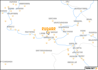
Rūdwār (Iran)Rūdwār is a town in Iran. An overview map of the region around Rūdwār is displayed below.
regional and 3d topo map of Rūdwār, Iran ::
Rūdwār airports ::
The nearest airport is QMJ - Masjed Soleiman Shahid Asyaee, located 117.9 km west of Rūdwār.
Other airports nearby include AWZ - Ahwaz (179.8 km west), MRX - Bandar Mahshahr Mahshahr (201.9 km south west), Nearby towns ::
Mamasanī (0.8km south west) //
Setār-e Khalīl (1.2km north) //
Arjol (1.7km south) //
Darreh Yās (1.9km south) //
Sar Mūr (1.7km east) //
Līrābī (2.1km west) //
Bāled (2.4km south east) //
Chelow (2.5km east) //
Āb Sardeh (3.2km south) //
Kāvand (3.2km south east) //
Korī Chahār Bīncheh (4.5km west) //
Sar Chāh (5.5km north) //
Āb Sardeh (4.9km west) //
Kūy-ye Chahār Bonīsheh (5.1km west) //
Āb Sardeh (5.1km west) //
Davāzdah Emām (5.5km north east) //
Deh Kohneh (5.3km north east) //
Sar Tang-e Maḩmūd (7.0km south) //
Nowtaragī (6.1km west) //
Haft Pīrān (6.2km east) //
Raḩīmābād (8.2km south east) //
Āb Sefīd (8.6km south east) //
Fīrūzābād (9.6km south east) //
Eslāmābād (9.8km south east) //
[all distances 'as the bird flies' and approximate] 
Disclaimer :: Information on this page comes without warranty of any kind |
||
|
Where is Rūdwār? Elevation and coordinates ::
Latitude (lat): 31°57'0"N Longitude (lon): 50°31'0"E
Elevation (approx.): 1807m (map arrows pan, magnifying glasses zoom) |
||
|
Visiting Rūdwār? Hotel/Accommodation ::
Book a hotel in Rūdwār Travel Guide ::
Buy a travel guide for Iran rental cars ::
car rental offers GPS waypoint ::
download a GPX waypoint (PoI) of Rūdwār for your GPS receiver
|
||