|
search place name
|
||
Sa‘ādatābād (Khūzestān, Iran)Sa‘ādatābād is a town in the Khūzestān region of Iran. An overview map of the region around Sa‘ādatābād is displayed below.
regional and 3d topo map of Sa‘ādatābād, Iran ::

Sa‘ādatābād airports ::
The nearest airport is MRX - Bandar Mahshahr Mahshahr, located 97.0 km west of Sa‘ādatābād.
Other airports nearby include BUZ - Bushehr (169.9 km south east), AWZ - Ahwaz (170.9 km north west), ABD - Abadan (183.2 km west), QMJ - Masjed Soleiman Shahid Asyaee (200.8 km north west), Nearby towns ::
Deh Bīsheh-ye Bālā (1.8km east) //
Qal‘eh-ye Kūchek (2.3km south west) //
Eslāmābād (2.4km north east) //
Shahr Kohneh (2.6km south) //
Tol Chegāh-e Pā'īn (2.9km south) //
‘Arabhā (3.0km north west) //
Cham (3.2km east) //
Tol Gavīneh (3.7km south west) //
Seyyed Naşīr od Dīn Moḩammad (3.7km north east) //
Deh-e Emāmzādeh (3.9km north east) //
Qal‘eh Ka‘bī (4.3km north) //
Borj-e Yūsefī (4.1km east) //
Tall-e Gorosneh (4.6km south east) //
Tol Gorosneh (4.7km south east) //
Dār ‘Alā'ī (4.8km west) //
Deh Now (5.1km east) //
Tol Chegāh-e Bālā (7.5km south east) //
Ḩājjī Qaşīr (7.4km west) //
Darūnak (7.5km west) //
Ābād (8.9km north west) //
[all distances 'as the bird flies' and approximate] 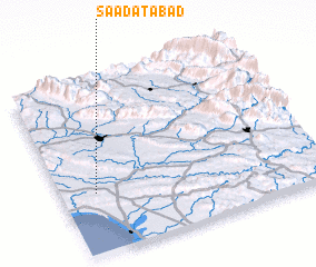 Places with similar names to Sa‘ādatābād, Iran ::
// Sidi Tabet (TN)
// Sādātābād (IR)
// Saādatābād (PK)
// Sa‘ādatābād (IR)
// Sa‘ādatābād (IR)
// Sa‘ādatābād (IR)
// Sa‘ādatābād (IR)
// Sa‘ādatābād (IR)
// Sa‘ādatābād (IR)
// Sa‘ādatābād (IR)
Disclaimer :: Information on this page comes without warranty of any kind |
||
|
Where is Sa‘ādatābād? Elevation and coordinates ::
Latitude (lat): 30°21'0"N Longitude (lon): 50°8'0"E
Elevation (approx.): 133m (map arrows pan, magnifying glasses zoom) |
||
|
Visiting Sa‘ādatābād? Hotel/Accommodation ::
Book a hotel in Sa‘ādatābād Travel Guide ::
Buy a travel guide for Iran rental cars ::
car rental offers GPS waypoint ::
download a GPX waypoint (PoI) of Sa‘ādatābād for your GPS receiver
|
||