|
search place name
|
||
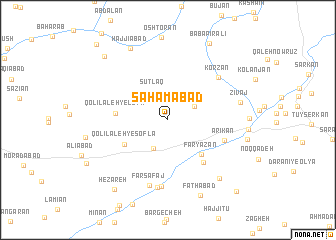
Sahāmābād (Hamadān, Iran)Sahāmābād is a town in the Hamadān region of Iran. An overview map of the region around Sahāmābād is displayed below.
regional and 3d topo map of Sahāmābād, Iran ::
Sahāmābād airports ::
The nearest airport is KSH - Bakhtaran Shahid Ashrafi Esfahani, located 107.7 km west of Sahāmābād.
Other airports nearby include SDG - Sanandaj (141.1 km north west), Nearby towns ::
Chālāb (2.9km north east) //
Sūtlaq (3.4km north west) //
Karīmābād (3.4km south west) //
Faryāzān (4.9km south east) //
Qolī Lāleh-ye Sofla (4.8km south west) //
Qolī Lāleh-ye ‘Olyā (4.9km west) //
Maḩmūdābād (5.8km south east) //
Ārīkān (5.7km south east) //
Korzān (6.7km north east) //
Amīrābād (7.5km south) //
Farasfaj (7.6km south) //
Farsafaj (7.5km south) //
Zīvaj (7.0km east) //
Qal‘eh-ye Bakhtīār (8.1km south east) //
Ḩājjīābād (8.7km north west) //
Ja‘farīyeh (7.6km east) //
Fatḩābād (9.0km south) //
Bābā Pīr ‘Alī (9.3km north east) //
Hezāreh (9.1km south west) //
Qol Qol (9.2km north west) //
Mālīcheh (10.1km south east) //
Gonbaleh (10.7km north west) //
[all distances 'as the bird flies' and approximate]  Places with similar names to Sahāmābād, Iran :: Disclaimer :: Information on this page comes without warranty of any kind |
||
|
Where is Sahāmābād? Elevation and coordinates ::
Latitude (lat): 34°33'10"N Longitude (lon): 48°18'12"E
Elevation (approx.): 1690m (map arrows pan, magnifying glasses zoom) |
||
|
Visiting Sahāmābād? Hotel/Accommodation ::
Book a hotel in Sahāmābād Travel Guide ::
Buy a travel guide for Iran rental cars ::
car rental offers GPS waypoint ::
download a GPX waypoint (PoI) of Sahāmābād for your GPS receiver
|
||