|
search place name
|
||
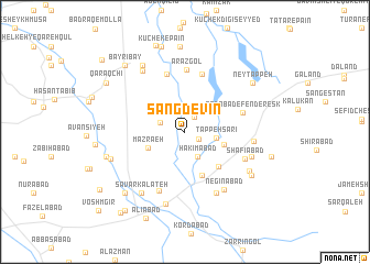
Sangdevīn (Golestān, Iran)Sangdevīn is a town in the Golestān region of Iran. An overview map of the region around Sangdevīn is displayed below.
regional and 3d topo map of Sangdevīn, Iran ::
Nearby towns ::
Ḩoseynābād-e Tappeh Sar (1.3km south east) //
Amīrābād (1.7km north east) //
Ḩājjī Kalāteh (2.2km north west) //
Ḩakīmābād (2.7km south east) //
Tappeh Sarī (2.6km east) //
Mazra‘eh (3.4km south west) //
Ma‘şūmābād (3.4km east) //
Reẕāābād (4.7km south) //
Āqsanābād (4.5km south east) //
Lāleh Bāgh (6.0km north) //
Moḩammad Javāl (6.0km north) //
Sa‘dābād-e Fenderesk (5.1km east) //
Arāz Gol (6.3km north) //
Mehdīābād (6.3km south) //
Shafī‘ābād (5.6km south east) //
Māzīārān (6.7km south) //
Ja‘farābād-e Nāmtalū (5.7km east) //
Negīnābād (6.7km south east) //
Dār Kalāteh (5.9km south east) //
Kūchek-e Bālā (7.0km north west) //
Sāvar Kalāteh (7.1km south west) //
Malek (7.5km south) //
Lāleh Bāgh (6.6km south east) //
Badrāq-e Ānāgaldī (7.6km north west) //
Qūshkorpī (6.6km south west) //
Naqīābād (7.0km south east) //
Ḩājjīābād (6.8km west) //
Khvosh Garpī (6.8km west) //
Ney Tappeh (7.4km north east) //
[all distances 'as the bird flies' and approximate]  Places with similar names to Sangdevīn, Iran :: Disclaimer :: Information on this page comes without warranty of any kind |
||
|
Where is Sangdevīn? Elevation and coordinates ::
Latitude (lat): 36°59'20"N Longitude (lon): 54°54'18"E
Elevation (approx.): 66m (map arrows pan, magnifying glasses zoom) |
||
|
Visiting Sangdevīn? Hotel/Accommodation ::
Book a hotel in Sangdevīn Travel Guide ::
Buy a travel guide for Iran rental cars ::
car rental offers GPS waypoint ::
download a GPX waypoint (PoI) of Sangdevīn for your GPS receiver
|
||