|
search place name
|
||
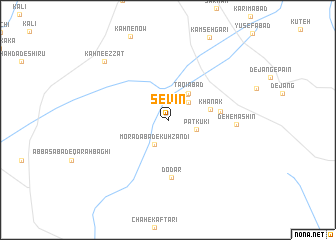
Sevīn (Sīstān va Balūchestān, Iran)Sevīn is a town in the Sīstān va Balūchestān region of Iran. An overview map of the region around Sevīn is displayed below.
regional and 3d topo map of Sevīn, Iran ::
Sevīn airports ::
The nearest airport is ZAH - Zahedan Intl, located 116.9 km north of Sevīn.
Nearby towns ::
Galangūr (2.8km north east) //
Kalūk-e Zangarī (3.0km south west) //
Morādābād-e Kūh Zandī (3.0km south west) //
Patkūkī (3.0km east) //
Kolangūr (3.4km north east) //
Landī (3.4km north east) //
Taqīābād (3.6km north east) //
Khānak (4.3km east) //
Khalīlābād (5.3km east) //
Do Dar (6.4km south) //
Deh-e Māshīn (6.8km east) //
Kahn-e ‘Ezzat (9.0km north west) //
[all distances 'as the bird flies' and approximate] 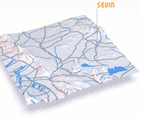 Places with similar names to Sevīn, Iran ::
Disclaimer :: Information on this page comes without warranty of any kind |
||
|
Where is Sevīn? Elevation and coordinates ::
Latitude (lat): 28°25'28"N Longitude (lon): 60°48'49"E
Elevation (approx.): 1596m (map arrows pan, magnifying glasses zoom) |
||
|
Visiting Sevīn? Hotel/Accommodation ::
Book a hotel in Sevīn Travel Guide ::
Buy a travel guide for Iran rental cars ::
car rental offers GPS waypoint ::
download a GPX waypoint (PoI) of Sevīn for your GPS receiver
|
||