|
search place name
|
||
Seyyed ‘Alī (Kordestān, Iran)Seyyed ‘Alī is a town in the Kordestān region of Iran. An overview map of the region around Seyyed ‘Alī is displayed below.
regional and 3d topo map of Seyyed ‘Alī, Iran ::

Seyyed ‘Alī airports ::
The nearest airport is SDG - Sanandaj, located 27.2 km north east of Seyyed ‘Alī.
Other airports nearby include KSH - Bakhtaran Shahid Ashrafi Esfahani (82.9 km south), Nearby towns ::
Dūlāb (0.9km east) //
Lā-ye Pol (3.4km north) //
Nezāz (3.7km west) //
Qolā-ye Mar (4.9km north) //
Vaşī-ye Soflá (5.4km north west) //
Sarchīn (5.6km south) //
Boz Lāneh (5.5km north east) //
Ţāy (5.7km south west) //
Deh Mūlā (5.3km east) //
Sarberāh (6.7km north) //
Āfarīn-e Bālā (6.8km south) //
Tārīk Now (6.6km north) //
Vaşī-ye ‘Olyā (7.0km north) //
Farajābād (6.5km south west) //
Fārsābād (6.8km south west) //
Hendīman (6.8km south west) //
Handīman (7.3km south west) //
Sang-e Sefīd (7.1km east) //
Kānī Qorbānī (8.4km north) //
Kānī Shalāneh (8.4km north) //
Noshūr-e Vosţá (7.2km east) //
Āfarīn-e Pā'īn (8.7km south) //
‘Askarān (8.1km north east) //
Hānī Vazmānī (8.9km north east) //
Savārīān (9.0km north east) //
Yamnān-e ‘Olyā (9.2km south east) //
[all distances 'as the bird flies' and approximate] 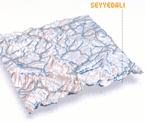 Places with similar names to Seyyed ‘Alī, Iran ::
Disclaimer :: Information on this page comes without warranty of any kind |
||
|
Where is Seyyed ‘Alī? Elevation and coordinates ::
Latitude (lat): 35°2'41"N Longitude (lon): 46°50'20"E
Elevation (approx.): 1466m (map arrows pan, magnifying glasses zoom) |
||
|
Visiting Seyyed ‘Alī? Hotel/Accommodation ::
Book a hotel in Seyyed ‘Alī Travel Guide ::
Buy a travel guide for Iran rental cars ::
car rental offers GPS waypoint ::
download a GPX waypoint (PoI) of Seyyed ‘Alī for your GPS receiver
|
||