|
search place name
|
||
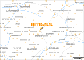
Seyyed Jalāl (Ostān-e Kermānshāh, Iran)Seyyed Jalāl is a town in the Ostān-e Kermānshāh region of Iran. An overview map of the region around Seyyed Jalāl is displayed below.
regional and 3d topo map of Seyyed Jalāl, Iran ::
Seyyed Jalāl airports ::
The nearest airport is KSH - Bakhtaran Shahid Ashrafi Esfahani, located 59.4 km south west of Seyyed Jalāl.
Other airports nearby include SDG - Sanandaj (63.3 km north west), Nearby towns ::
Saţar (1.0km south west) //
Cheshmeh Qal‘eh (2.4km south west) //
Bābā Sheykh ‘Alī (3.7km south) //
Marzāleh (3.6km north west) //
Darband (3.6km south west) //
Shūrābād (4.2km south east) //
Charkhalān (4.6km west) //
Āsemān Dūl (4.9km west) //
Cheshmeh-ye Bahāʼ od Dīn (5.5km north west) //
Khalīfeh (6.1km north east) //
Darvāzeh (6.3km south west) //
Shāh Godār (7.0km south east) //
Jūbsāz (7.4km north) //
Deh Sheykh (7.6km north) //
Dāshtī Bolāghī (6.4km east) //
Nokhvod Tappeh (7.1km south east) //
Jūbkabūd-e ‘Olyā (7.2km north east) //
Khanjarābād (7.2km south east) //
Choqerchāh (8.0km north) //
Ā'īnalah (8.0km south) //
Būrakābād (8.1km south) //
Galovīj (8.8km south) //
Jūb Kabūd-e Soflá (8.5km north east) //
Deh Soleymān (8.7km north east) //
Sardarreh (8.2km south west) //
Dogolbandeh (8.2km north west) //
[all distances 'as the bird flies' and approximate]  Places with similar names to Seyyed Jalāl, Iran ::
// Sidi Jilali (MA)
Disclaimer :: Information on this page comes without warranty of any kind |
||
|
Where is Seyyed Jalāl? Elevation and coordinates ::
Latitude (lat): 34°49'0"N Longitude (lon): 47°28'0"E
Elevation (approx.): 1679m (map arrows pan, magnifying glasses zoom) |
||
|
Visiting Seyyed Jalāl? Hotel/Accommodation ::
Book a hotel in Seyyed Jalāl Travel Guide ::
Buy a travel guide for Iran rental cars ::
car rental offers GPS waypoint ::
download a GPX waypoint (PoI) of Seyyed Jalāl for your GPS receiver
|
||