|
search place name
|
||
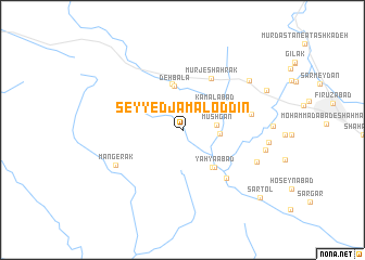
Seyyed Jamāl od Dīn (Fārs, Iran)Seyyed Jamāl od Dīn is a town in the Fārs region of Iran. An overview map of the region around Seyyed Jamāl od Dīn is displayed below.
regional and 3d topo map of Seyyed Jamāl od Dīn, Iran ::
Seyyed Jamāl od Dīn airports ::
The nearest airport is SYZ - Shiraz Shahid Dastghaib Intl, located 81.0 km north of Seyyed Jamāl od Dīn.
Other airports nearby include BUZ - Bushehr (156.5 km west), Nearby towns ::
Mūshgān (3.1km east) //
Deh Now (3.3km north east) //
Nowdarān (3.4km east) //
Kamālābād (3.8km north east) //
Deh Bālā (4.6km north) //
Bāyegān (4.8km north) //
Dowlatābād (4.8km south east) //
Yaḩyáābād (4.8km south east) //
Mūrj-e Shahrak (5.9km north east) //
Deh Bīn (6.4km south east) //
Sahlābād (6.4km east) //
Mangerak (7.0km south west) //
Deh Bīn (7.5km south east) //
Deh Barm (7.9km north east) //
Dowlatābād (7.8km east) //
Aḩmadābād (8.6km north east) //
Sar Tol (9.8km south east) //
[all distances 'as the bird flies' and approximate] 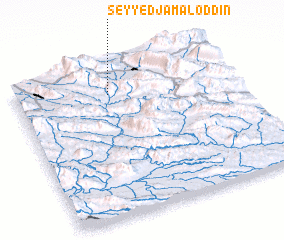 Places with similar names to Seyyed Jamāl od Dīn, Iran ::
// Seyyed Jamāl od Dīn (IR)
Disclaimer :: Information on this page comes without warranty of any kind |
||
|
Where is Seyyed Jamāl od Dīn? Elevation and coordinates ::
Latitude (lat): 28°49'17"N Longitude (lon): 52°25'57"E
Elevation (approx.): 1306m (map arrows pan, magnifying glasses zoom) |
||
|
Visiting Seyyed Jamāl od Dīn? Hotel/Accommodation ::
Book a hotel in Seyyed Jamāl od Dīn Travel Guide ::
Buy a travel guide for Iran rental cars ::
car rental offers GPS waypoint ::
download a GPX waypoint (PoI) of Seyyed Jamāl od Dīn for your GPS receiver
|
||