|
search place name
|
||
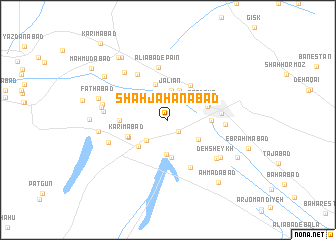
Shāh Jahānābād (Kermān, Iran)Shāh Jahānābād is a town in the Kermān region of Iran. An overview map of the region around Shāh Jahānābād is displayed below.
regional and 3d topo map of Shāh Jahānābād, Iran ::
Shāh Jahānābād airports ::
The nearest airport is KER - Kerman, located 72.2 km south east of Shāh Jahānābād.
Nearby towns ::
Moḩammadābād (1.6km south east) //
Noşratābād (3.3km north) //
Jalīān (3.3km north) //
Hemmatābād (3.1km south west) //
Soleymānābād (3.4km north) //
Dowlatābād (3.9km south) //
‘Abbāsābād (3.6km south east) //
Na‘īmābād (4.1km north) //
Tolombeh-ye Arbāb‘alī (4.2km south) //
Kheyrābād (4.1km south west) //
Ferdows (4.0km north east) //
Zarandū'īyeh (4.0km east) //
Deh Chenār (4.4km north east) //
Feyẕābād (4.2km south west) //
Ḩoseynābād (4.2km south west) //
Reyḩān (4.3km north east) //
Karīmābād (4.3km south west) //
Akbarābād (4.2km east) //
Ḩasanābād (4.6km west) //
Taqīābād (5.7km south) //
‘Alīābād-e Pā'īn (5.9km north) //
Zarand (5.2km east) //
Z̄owqābād (5.9km north west) //
Ḩoseynābād (5.5km east) //
Deh Sheykh (6.3km south east) //
Deh Īraj (6.2km south west) //
Moḩammadābād-e Golshan (6.8km north west) //
Tolombeh-ye Kheyrābād (6.6km south east) //
Sa‘īdābād (6.3km west) //
[all distances 'as the bird flies' and approximate]  Places with similar names to Shāh Jahānābād, Iran ::
// Shāh Jahānābād (IR)
// Shāhjahānābād (PK)
Disclaimer :: Information on this page comes without warranty of any kind |
||
|
Where is Shāh Jahānābād? Elevation and coordinates ::
Latitude (lat): 30°48'15"N Longitude (lon): 56°30'49"E
Elevation (approx.): 1644m (map arrows pan, magnifying glasses zoom) |
||
|
Visiting Shāh Jahānābād? Hotel/Accommodation ::
Book a hotel in Shāh Jahānābād Travel Guide ::
Buy a travel guide for Iran rental cars ::
car rental offers GPS waypoint ::
download a GPX waypoint (PoI) of Shāh Jahānābād for your GPS receiver
|
||