|
search place name
|
||
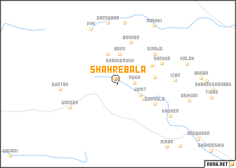
Shahr-e Bālā (Hormozgān, Iran)Shahr-e Bālā is a town in the Hormozgān region of Iran. An overview map of the region around Shahr-e Bālā is displayed below.
regional and 3d topo map of Shahr-e Bālā, Iran ::
Shahr-e Bālā airports ::
The nearest airport is BND - Bandar Abbass Intl, located 151.8 km north west of Shahr-e Bālā.
Other airports nearby include KHS - Khasab (163.4 km west), RKT - Ras Al Khaimah Intl (218.5 km south west), FJR - Fujeirah Fujairah Intl (226.4 km south west), Nearby towns ::
Rūkh (2.4km east) //
Shahverūkh (2.9km north) //
Jūmīt (3.6km south east) //
Bā'īnī (4.7km north) //
Shahr-e Bast (4.4km south east) //
Mesek (4.9km north) //
Māgī-ye Shah Varūkh (5.3km east) //
Māgī Mordeh (5.7km north east) //
Sarmalā (6.2km south east) //
Bannar (6.8km north) //
Gī Majg (7.0km north east) //
Sarhūr (7.0km north east) //
Dargon (7.8km south west) //
Vīhī (9.5km north west) //
Khūmen (9.1km south east) //
[all distances 'as the bird flies' and approximate]  Places with similar names to Shahr-e Bālā, Iran ::
// Chiarbola (IT)
// Chorobel (PL)
// Chāh Gharbāl (IR)
// Chīr-e Bālā (IR)
// Char Boāil (BD)
// Shahr-e Bālā (IR)
// Charbal (PK)
// Chirāgh Bela (PK)
// Chirāgh Bela (PK)
// Chorobal (PE)
Disclaimer :: Information on this page comes without warranty of any kind |
||
|
Where is Shahr-e Bālā? Elevation and coordinates ::
Latitude (lat): 26°40'28"N Longitude (lon): 57°46'50"E
Elevation (approx.): 1521m (map arrows pan, magnifying glasses zoom) |
||
|
Visiting Shahr-e Bālā? Hotel/Accommodation ::
Book a hotel in Shahr-e Bālā Travel Guide ::
Buy a travel guide for Iran rental cars ::
car rental offers GPS waypoint ::
download a GPX waypoint (PoI) of Shahr-e Bālā for your GPS receiver
|
||