|
search place name
|
||
Shāhzādeh ‘Alīakbar (Iran)Shāhzādeh ‘Alīakbar is a town in Iran. An overview map of the region around Shāhzādeh ‘Alīakbar is displayed below.
regional and 3d topo map of Shāhzādeh ‘Alīakbar, Iran ::
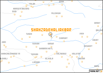
Nearby towns ::
Chālū (0.3km south) //
Emāmzādeh Moḩammad Morād (1.5km east) //
Manzel Darreh (2.8km west) //
Sanūr (3.7km south) //
Chargat (4.0km south east) //
Emāmzādeh Ebrāhīm (5.8km south) //
Shā‘bān Kheyl (5.8km south) //
Īvel (6.4km south) //
Terkām (5.8km south west) //
Nīleh Kūh (7.6km north) //
Tūseh (6.4km west) //
Kalkenār (8.0km south) //
Deym Dasht (8.0km north) //
Kīā Kolā (8.0km south) //
Kūtmār (8.7km south west) //
Kord Mīr (8.8km south east) //
Ter Kām (9.1km south west) //
Telmā Darreh (9.7km south east) //
Zangolī (9.5km south east) //
Fīk Cheshmeh (9.5km south east) //
[all distances 'as the bird flies' and approximate] 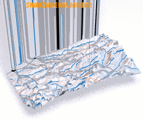 Places with similar names to Shāhzādeh ‘Alīakbar, Iran :: Disclaimer :: Information on this page comes without warranty of any kind |
||
|
Where is Shāhzādeh ‘Alīakbar? Elevation and coordinates ::
Latitude (lat): 36°18'0"N Longitude (lon): 53°40'0"E
Elevation (approx.): 1274m (map arrows pan, magnifying glasses zoom) |
||
|
Visiting Shāhzādeh ‘Alīakbar? Hotel/Accommodation ::
Book a hotel in Shāhzādeh ‘Alīakbar Travel Guide ::
Buy a travel guide for Iran rental cars ::
car rental offers GPS waypoint ::
download a GPX waypoint (PoI) of Shāhzādeh ‘Alīakbar for your GPS receiver
|
||