|
search place name
|
||
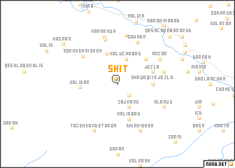
Shīt (Iran)Shīt is a town in Iran. An overview map of the region around Shīt is displayed below.
regional and 3d topo map of Shīt, Iran ::
Shīt airports ::
The nearest airport is RAS - Rasht, located 91.1 km north east of Shīt.
Other airports nearby include RZR - Ramsar (177.9 km east), SDG - Sanandaj (243.3 km south west), Nearby towns ::
Ālūmīnīom (2.4km south east) //
Jūjergān (2.4km south east) //
Zāj Kand (4.0km south) //
Kolūchābād (4.1km north) //
Koleh Sīrān (5.0km north) //
Shaqāqī-ye Jezlā (4.4km east) //
Jezlā (4.8km north east) //
Valīābād (5.8km south) //
Qeshlāq-e Anz̄ar (5.3km north east) //
Valīdar (4.8km west) //
Sorkheh Mīsheh (6.2km north west) //
Karmālīm (7.3km north) //
Gowhar (7.2km north) //
Qeshlāq-e Jezlā (6.2km east) //
Kolūch (7.7km north) //
Kamarkūh (7.8km north) //
Anz̄ar (6.8km north east) //
Tāzeh Kand-e Ţārom (8.0km south) //
Shīrmīsheh (8.0km south) //
A‘lārūd (7.0km south east) //
Kasrān (9.4km north west) //
Qeshlāq-e Banārūd (10.0km north east) //
[all distances 'as the bird flies' and approximate]  Places with similar names to Shīt, Iran ::
Disclaimer :: Information on this page comes without warranty of any kind |
||
|
Where is Shīt? Elevation and coordinates ::
Latitude (lat): 36°58'0"N Longitude (lon): 48°41'0"E
Elevation (approx.): 1190m (map arrows pan, magnifying glasses zoom) |
||
|
Visiting Shīt? Hotel/Accommodation ::
Book a hotel in Shīt Travel Guide ::
Buy a travel guide for Iran rental cars ::
car rental offers GPS waypoint ::
download a GPX waypoint (PoI) of Shīt for your GPS receiver
|
||