|
search place name
|
||
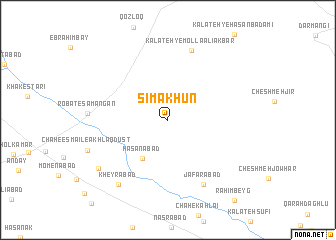
Sīmākhūn (Khorāsān, Iran)Sīmākhūn is a town in the Khorāsān region of Iran. An overview map of the region around Sīmākhūn is displayed below.
regional and 3d topo map of Sīmākhūn, Iran ::
Sīmākhūn airports ::
The nearest airport is HEA - Herat, located 228.0 km south east of Sīmākhūn.
Nearby towns ::
Ḩasanābād (4.9km south west) //
Ja‘farābād (7.8km south east) //
Kalāteh-ye Mollā ‘Alī Akbar (8.1km north) //
Kheyrābād (8.5km south west) //
Chāh-e Moşţafá Akhlāq Dūst (8.3km south west) //
[all distances 'as the bird flies' and approximate]  Places with similar names to Sīmākhūn, Iran ::
// Xóm Cầu Hin (VN)
// Xóm Cả Huấn (VN)
// Xóm Khánh Hòa (VN)
// Xóm Khiên (VN)
// Xóm Khon (VN)
// Samokhin (RU)
// Samokhino (RU)
// Samukhino (RU)
// Semakhiny (RU)
// Semukhina (RU)
Disclaimer :: Information on this page comes without warranty of any kind |
||
|
Where is Sīmākhūn? Elevation and coordinates ::
Latitude (lat): 35°31'38"N Longitude (lon): 60°18'51"E
Elevation (approx.): 1178m (map arrows pan, magnifying glasses zoom) |
||
|
Visiting Sīmākhūn? Hotel/Accommodation ::
Book a hotel in Sīmākhūn Travel Guide ::
Buy a travel guide for Iran rental cars ::
car rental offers GPS waypoint ::
download a GPX waypoint (PoI) of Sīmākhūn for your GPS receiver
|
||