|
search place name
|
||
Şūf‘alī Kandī (Ostān-e Āz̄arbāyjān-e Gharbī, Iran)Şūf‘alī Kandī is a town in the Ostān-e Āz̄arbāyjān-e Gharbī region of Iran. An overview map of the region around Şūf‘alī Kandī is displayed below.
regional and 3d topo map of Şūf‘alī Kandī, Iran ::

Şūf‘alī Kandī airports ::
The nearest airport is VAN - Van, located 118.6 km south west of Şūf‘alī Kandī.
Nearby towns ::
Nādū (1.3km west) //
Pīr Ahmad Kandī (2.8km north) //
Salmānābād (4.0km north east) //
Beyk Kandī (3.8km east) //
Qayān Kandī (4.9km north) //
Jamāl Kandī (5.0km north west) //
Kelīsā Kandī (4.6km south east) //
Ţahmāseb Kandī (5.4km south east) //
Soleymān Āghol (5.7km north west) //
Nefţū (6.7km north east) //
‘Arab Dīzaj (6.6km south east) //
Uzunyol (6.7km south west) //
Kızılkaya (7.5km north west) //
Başköy (8.7km north) //
Qolīdīzaj (8.0km south east) //
Kızılkent (8.4km north west) //
Dağdelen (9.5km north east) //
Delakverdī (9.8km south east) //
[all distances 'as the bird flies' and approximate] 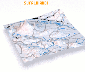 Places with similar names to Şūf‘alī Kandī, Iran ::
// Seyf‘alī Kandī (IR)
Disclaimer :: Information on this page comes without warranty of any kind |
||
|
Where is Şūf‘alī Kandī? Elevation and coordinates ::
Latitude (lat): 39°20'57"N Longitude (lon): 44°6'20"E
Elevation (approx.): 2204m (map arrows pan, magnifying glasses zoom) |
||
|
Visiting Şūf‘alī Kandī? Hotel/Accommodation ::
Book a hotel in Şūf‘alī Kandī Travel Guide ::
Buy a travel guide for Iran rental cars ::
car rental offers GPS waypoint ::
download a GPX waypoint (PoI) of Şūf‘alī Kandī for your GPS receiver
|
||