|
search place name
|
||
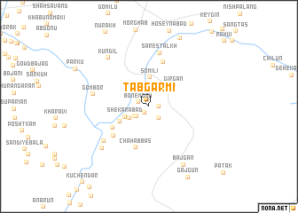
Tabgarmī (Kermān, Iran)Tabgarmī is a town in the Kermān region of Iran. An overview map of the region around Tabgarmī is displayed below.
regional and 3d topo map of Tabgarmī, Iran ::
Tabgarmī airports ::
The nearest airport is BND - Bandar Abbass Intl, located 113.0 km south west of Tabgarmī.
Other airports nearby include KHS - Khasab (201.8 km south west), Nearby towns ::
Sīāhābād (1.0km south west) //
Salānīābād (1.1km east) //
Bon-e Mogh (1.3km north west) //
Konīūn (1.8km south east) //
Kondar (1.8km south west) //
Kandar (2.0km south west) //
Gharībābād (2.7km south west) //
Shekarābād (3.0km south west) //
Somīlī (3.6km north) //
Gīrgān (3.8km north east) //
Pā Kūh (3.7km south west) //
Deh Park (4.8km south west) //
Chāh ‘Abbās (5.4km south) //
Balūchābād (5.4km south west) //
Kūchūngarī (5.8km north) //
Sares Talkh (6.8km north) //
Garmāhī (6.7km south west) //
Gom Bor (6.4km west) //
Deh Mīān (7.4km south west) //
Kūndīl (7.6km north west) //
Bajgān (8.3km south east) //
Sagnān (9.3km north) //
Gājgūn (9.9km south east) //
[all distances 'as the bird flies' and approximate] 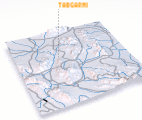 Places with similar names to Tabgarmī, Iran ::
// Debagrām (BD)
// Debagrām (IN)
// Diabakrom (GH)
// Tebekrom (GH)
// Débi Kouroumba (ML)
// Tebicuary Mí (PY)
Disclaimer :: Information on this page comes without warranty of any kind |
||
|
Where is Tabgarmī? Elevation and coordinates ::
Latitude (lat): 27°39'48"N Longitude (lon): 57°24'21"E
Elevation (approx.): 508m (map arrows pan, magnifying glasses zoom) |
||
|
Visiting Tabgarmī? Hotel/Accommodation ::
Book a hotel in Tabgarmī Travel Guide ::
Buy a travel guide for Iran rental cars ::
car rental offers GPS waypoint ::
download a GPX waypoint (PoI) of Tabgarmī for your GPS receiver
|
||