|
search place name
|
||
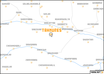
Ţahmūres̄ (Kordestān, Iran)Ţahmūres̄ is a town in the Kordestān region of Iran. An overview map of the region around Ţahmūres̄ is displayed below.
regional and 3d topo map of Ţahmūres̄, Iran ::
Ţahmūres̄ airports ::
The nearest airport is SDG - Sanandaj, located 74.6 km south west of Ţahmūres̄.
Other airports nearby include KSH - Bakhtaran Shahid Ashrafi Esfahani (154.6 km south), RAS - Rasht (253.8 km north east), Nearby towns ::
Āq Kand Pā'īn (3.7km north) //
Dowlatyār (4.3km north) //
Shebertū (4.8km north east) //
Sabzevār (4.9km west) //
Bāqerābād (4.9km east) //
Kherzdīn (6.3km south west) //
Āgh Kand-e ‘Olyā (6.3km north east) //
Cheshmeh Ādīneh (5.8km north east) //
Qadīm Khān (6.9km south) //
Sīrlān (7.6km north) //
Şādeqābād (7.1km south west) //
Chehel Amīrān (8.0km north) //
Qezel Āghāj (7.1km north east) //
Golbāgh-e Soflá (8.2km north west) //
Ashrafābād (10.4km south east) //
[all distances 'as the bird flies' and approximate] 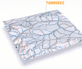 Places with similar names to Ţahmūres̄, Iran ::
Disclaimer :: Information on this page comes without warranty of any kind |
||
|
Where is Ţahmūres̄? Elevation and coordinates ::
Latitude (lat): 35°41'0"N Longitude (lon): 47°38'0"E
Elevation (approx.): 1938m (map arrows pan, magnifying glasses zoom) |
||
|
Visiting Ţahmūres̄? Hotel/Accommodation ::
Book a hotel in Ţahmūres̄ Travel Guide ::
Buy a travel guide for Iran rental cars ::
car rental offers GPS waypoint ::
download a GPX waypoint (PoI) of Ţahmūres̄ for your GPS receiver
|
||