|
search place name
|
||
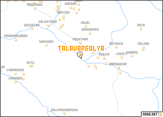
Ţalāvar-e ‘Olyā (Khūzestān, Iran)Ţalāvar-e ‘Olyā is a town in the Khūzestān region of Iran. An overview map of the region around Ţalāvar-e ‘Olyā is displayed below.
regional and 3d topo map of Ţalāvar-e ‘Olyā, Iran ::
Ţalāvar-e ‘Olyā airports ::
The nearest airport is QMJ - Masjed Soleiman Shahid Asyaee, located 103.7 km north west of Ţalāvar-e ‘Olyā.
Other airports nearby include AWZ - Ahwaz (122.8 km west), MRX - Bandar Mahshahr Mahshahr (123.0 km south west), ABD - Abadan (205.4 km south west), Nearby towns ::
Ţalāvar-e Soflá (0.1km north west) //
Monjvek (2.3km south east) //
Jalāl Do Barān (2.5km north) //
Şeydūn (2.6km north east) //
Mīān Bīsheh (2.9km north west) //
Darreh Bonīāb (3.1km south east) //
Posht Par (3.6km north) //
Chal Sorkh (3.3km east) //
Darreh Zard (3.6km south east) //
Savālī (4.3km west) //
Rūdzīr (4.5km east) //
A‘lā (5.0km east) //
Sar Darreh (6.0km north) //
Vājel (7.4km north) //
Pātāveh (7.3km east) //
Sarkhānī (7.5km north west) //
Dūrtū (8.3km north west) //
Eslāmābād (8.4km north west) //
Bon Shovār (7.6km east) //
Jūler (9.8km north west) //
Kaleh-ye Pīr (10.0km north west) //
[all distances 'as the bird flies' and approximate]  Places with similar names to Ţalāvar-e ‘Olyā, Iran :: Disclaimer :: Information on this page comes without warranty of any kind |
||
|
Where is Ţalāvar-e ‘Olyā? Elevation and coordinates ::
Latitude (lat): 31°20'55"N Longitude (lon): 50°3'10"E
Elevation (approx.): 831m (map arrows pan, magnifying glasses zoom) |
||
|
Visiting Ţalāvar-e ‘Olyā? Hotel/Accommodation ::
Book a hotel in Ţalāvar-e ‘Olyā Travel Guide ::
Buy a travel guide for Iran rental cars ::
car rental offers GPS waypoint ::
download a GPX waypoint (PoI) of Ţalāvar-e ‘Olyā for your GPS receiver
|
||