|
search place name
|
||
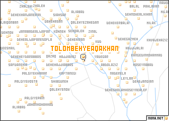
Tolombeh-ye Āqā Khān (Sīstān va Balūchestān, Iran)Tolombeh-ye Āqā Khān is a town in the Sīstān va Balūchestān region of Iran. An overview map of the region around Tolombeh-ye Āqā Khān is displayed below.
regional and 3d topo map of Tolombeh-ye Āqā Khān, Iran ::
Tolombeh-ye Āqā Khān airports ::
The nearest airport is ZAH - Zahedan Intl, located 174.7 km south west of Tolombeh-ye Āqā Khān.
Nearby towns ::
Gorgīj (0.1km west) //
Deh-e Mollā Ḩoseyn (1.6km west) //
Borj-e Sarband (1.6km west) //
Nārū'ī Va Shahrakī (1.9km north) //
Shahrestān-e Kohneh (1.6km east) //
Fatḩī Khān (1.9km north) //
Jalālī (1.9km north) //
Ebrāhīmābād (1.6km east) //
Kalaf Bāz (2.4km south west) //
Deh-e Karam Shāh (2.4km north west) //
Deh-e Mūsá Shahbāz (2.4km north west) //
Deh-e ‘Abbās Rostam (2.4km north east) //
Zehak (2.3km east) //
Malek Ḩeydarī (3.2km north) //
Deh-e Sarḩaddī (3.2km west) //
Deh-e Mastīān (3.2km west) //
Ḩājjī ‘Avaz (3.2km west) //
Deh-e Sāmānī (3.2km west) //
Deh-e Āzād (3.2km east) //
Oshtorak (3.2km east) //
Yādegār (3.2km east) //
Afẕal (3.2km east) //
Deh-e Mīrān (4.0km north west) //
Kūd (4.0km north east) //
Shahrestān-e Aḩmad ‘Alī Khān (3.7km south east) //
Mīrzā Ākhūnd (3.7km north east) //
Kūd (4.2km north east) //
Zahak (5.2km north) //
Kaftāregī (4.9km south west) //
[all distances 'as the bird flies' and approximate]  Places with similar names to Tolombeh-ye Āqā Khān, Iran :: Disclaimer :: Information on this page comes without warranty of any kind |
||
|
Where is Tolombeh-ye Āqā Khān? Elevation and coordinates ::
Latitude (lat): 30°54'0"N Longitude (lon): 61°41'0"E
Elevation (approx.): 490m (map arrows pan, magnifying glasses zoom) |
||
|
Visiting Tolombeh-ye Āqā Khān? Hotel/Accommodation ::
Book a hotel in Tolombeh-ye Āqā Khān Travel Guide ::
Buy a travel guide for Iran rental cars ::
car rental offers GPS waypoint ::
download a GPX waypoint (PoI) of Tolombeh-ye Āqā Khān for your GPS receiver
|
||