|
search place name
|
||
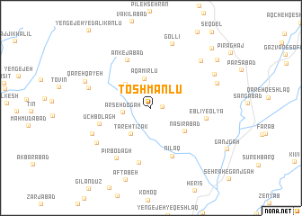
Toshmanlū (Ardabīl, Iran)Toshmanlū is a town in the Ardabīl region of Iran. An overview map of the region around Toshmanlū is displayed below.
regional and 3d topo map of Toshmanlū, Iran ::
Toshmanlū airports ::
The nearest airport is RAS - Rasht, located 134.7 km east of Toshmanlū.
Other airports nearby include TBZ - Tabriz Intl (176.0 km west), Nearby towns ::
Pargū (1.1km east) //
‘Arşeh Dogāh (2.8km west) //
Āqā Mīrlū (3.7km north) //
Tareh Tīzak (3.7km south west) //
Tabrīzaq (3.7km south west) //
Shahsavārlū (3.9km north west) //
Naşīrābād (4.4km south east) //
Nīlaq (6.3km south) //
Ānkejābād (6.4km north) //
Ūch Bolāgh (5.5km west) //
Pardastlū (6.8km south) //
Eblī-ye ‘Olyā (5.6km east) //
Eblī-ye Soflá (5.6km east) //
Pīr Bodāgh (7.1km south west) //
Bāghcheh Jīq (6.6km south west) //
Qeshlāq (6.9km south west) //
Kallehgāh (6.6km west) //
Gollī (8.2km north) //
Asfaranjān-e Jadīd (7.6km north east) //
Pīrahnī (7.2km north east) //
Lakandasht (7.5km north east) //
Qareh Qayeh (7.3km north west) //
Āftābeh (9.2km south) //
Asfaranjān (8.8km north east) //
Golqeshlāq (9.5km north east) //
[all distances 'as the bird flies' and approximate] 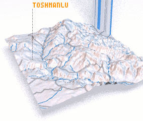
Disclaimer :: Information on this page comes without warranty of any kind |
||
|
Where is Toshmanlū? Elevation and coordinates ::
Latitude (lat): 37°44'46"N Longitude (lon): 48°10'34"E
Elevation (approx.): 1748m (map arrows pan, magnifying glasses zoom) |
||
|
Visiting Toshmanlū? Hotel/Accommodation ::
Book a hotel in Toshmanlū Travel Guide ::
Buy a travel guide for Iran rental cars ::
car rental offers GPS waypoint ::
download a GPX waypoint (PoI) of Toshmanlū for your GPS receiver
|
||