|
search place name
|
||
Yāl Fartakon (Khorāsān, Iran)Yāl Fartakon is a town in the Khorāsān region of Iran. An overview map of the region around Yāl Fartakon is displayed below.
regional and 3d topo map of Yāl Fartakon, Iran ::
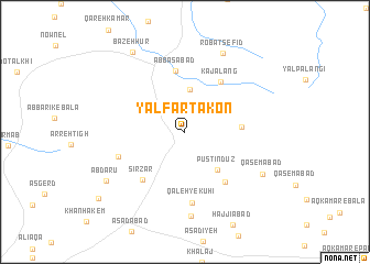
Nearby towns ::
Seyyed Aḩmad (4.3km north) //
Pūstīn Dūz (4.7km south east) //
Zīārat (4.7km east) //
Kaj Alang (5.9km north east) //
‘Abbāsābād (6.3km north) //
Kalāteh-ye Ma‘dan (6.0km south east) //
Sīrzār (6.0km south west) //
Qal'eh-ye Kūhī (7.2km south) //
Gardaneh-ye Moḩammad Mīrzā (6.1km south west) //
Shīleh Goshād (8.5km south) //
Robāţ Sefīd (8.6km north) //
Qāsemābād (7.7km south east) //
Ābdārū (8.2km south west) //
Bāzeh Ḩūr (9.2km north west) //
‘Alāqeh (9.8km south west) //
[all distances 'as the bird flies' and approximate] 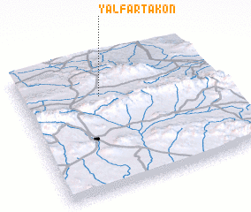 Places with similar names to Yāl Fartakon, Iran :: Disclaimer :: Information on this page comes without warranty of any kind |
||
|
Where is Yāl Fartakon? Elevation and coordinates ::
Latitude (lat): 35°43'6"N Longitude (lon): 59°24'21"E
Elevation (approx.): 2135m (map arrows pan, magnifying glasses zoom) |
||
|
Visiting Yāl Fartakon? Hotel/Accommodation ::
Book a hotel in Yāl Fartakon Travel Guide ::
Buy a travel guide for Iran rental cars ::
car rental offers GPS waypoint ::
download a GPX waypoint (PoI) of Yāl Fartakon for your GPS receiver
|
||