|
search place name
|
||
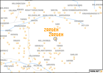
Zardeh (Ostān-e Kermānshāh, Iran)Zardeh is a town in the Ostān-e Kermānshāh region of Iran. An overview map of the region around Zardeh is displayed below.
regional and 3d topo map of Zardeh, Iran ::
Zardeh airports ::
The nearest airport is KSH - Bakhtaran Shahid Ashrafi Esfahani, located 114.3 km east of Zardeh.
Other airports nearby include SDG - Sanandaj (124.2 km north east), Nearby towns ::
Seyyed Moḩammad-e Zardeh (1.4km north west) //
Zardeh (2.2km south east) //
Ramakī-ye ‘Olyā (3.3km north) //
Mollā Kabūd (3.2km south west) //
Bān Zardeh (3.4km south east) //
Sīān (4.0km north east) //
Ramakī-ye Soflá (4.0km north east) //
Qol Qoleh (4.4km south) //
Kānī Pāzīz (4.8km south west) //
Qūjī Bāshī (4.8km south west) //
Yārān (4.9km south east) //
Mīvalī-ye Soflá (5.5km north) //
Pīrān (6.1km south) //
Meleh Kabūd (5.6km south west) //
Kānī ‘Azīz (5.6km south west) //
Dārāb (6.2km south) //
Kānī Sorkheh (6.2km south) //
Balvān (6.3km south) //
Salmān Tappeh (6.5km south) //
Gūsh Korī (6.6km south) //
Mīvalī-ye ‘Olyā (6.9km north) //
Kānī Rash (6.9km south) //
Elyāsī-ye Şāleḩ Maţţā‘ (7.2km north) //
Kolāh Māl (7.5km south) //
Nāvehfereh (7.1km south west) //
Zhālekeh-ye Ḩoseyn (8.0km south) //
Kānī Vā (7.2km north west) //
Ḩabīb Reẕā Veys (7.9km south) //
Bezmīrābād (7.6km north east) //
[all distances 'as the bird flies' and approximate]  Places with similar names to Zardeh, Iran ::
Disclaimer :: Information on this page comes without warranty of any kind |
||
|
Where is Zardeh? Elevation and coordinates ::
Latitude (lat): 34°33'18"N Longitude (lon): 45°56'25"E
Elevation (approx.): 1013m (map arrows pan, magnifying glasses zoom) |
||
|
Visiting Zardeh? Hotel/Accommodation ::
Book a hotel in Zardeh Travel Guide ::
Buy a travel guide for Iran rental cars ::
car rental offers GPS waypoint ::
download a GPX waypoint (PoI) of Zardeh for your GPS receiver
|
||