|
search place name
|
||
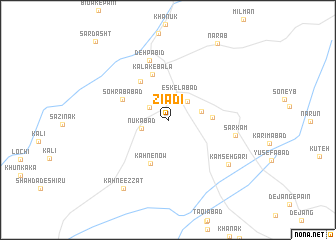
Zīādī (Sīstān va Balūchestān, Iran)Zīādī is a town in the Sīstān va Balūchestān region of Iran. An overview map of the region around Zīādī is displayed below.
regional and 3d topo map of Zīādī, Iran ::
Zīādī airports ::
The nearest airport is ZAH - Zahedan Intl, located 103.0 km north of Zīādī.
Nearby towns ::
Sīāh Tīreh-ye Pā'īn (2.3km north west) //
Gūnak (2.8km north east) //
Eskelābād (3.0km north) //
Nūkābād (2.8km west) //
Goz̄ar Māhī (3.4km east) //
Gūshān (4.4km east) //
Kahn-e Now (5.2km south) //
Kalak-e Pā'īn (5.1km north west) //
Kalak-e Bālā (5.3km north) //
Sohrābābād (5.0km north west) //
Deh Pābīd (6.9km north) //
Sar Kam (6.8km east) //
Kamseh Garī (7.7km south east) //
Kahn-e ‘Ezzat (8.8km south west) //
Narāb (9.9km north east) //
Sardasht (11.3km north west) //
[all distances 'as the bird flies' and approximate]  Places with similar names to Zīādī, Iran ::
Disclaimer :: Information on this page comes without warranty of any kind |
||
|
Where is Zīādī? Elevation and coordinates ::
Latitude (lat): 28°33'7"N Longitude (lon): 60°47'40"E
Elevation (approx.): 1694m (map arrows pan, magnifying glasses zoom) |
||
|
Visiting Zīādī? Hotel/Accommodation ::
Book a hotel in Zīādī Travel Guide ::
Buy a travel guide for Iran rental cars ::
car rental offers GPS waypoint ::
download a GPX waypoint (PoI) of Zīādī for your GPS receiver
|
||